
District Establishment Year- 10.05.1981
Geographical Status of Khagaria -
Longitude - Khagaria District - 250 15" to 250 44"
Latitude - Khagaria District - 860 17.14 " to 860 52.5. "
Area -1485.8 Sq.K.m. or 147798.64 Hectare or 369037 Acre
Extended Length and Width of the District& North to South - 23 K.m, East to west - 48 K.m.
Rivers Ganga, Burhi Gandak, Bagmati, Koshi, Kareh, Kamla
Major Crops:- Paddy, Maize, Wheat, Oilseed and Vegetables
Surrounded districts
North- Saharsa District
South- Munger and Begusarai District
East- Bhagalpur and Madhepura District
West- Begusarai and Samastipur Districts
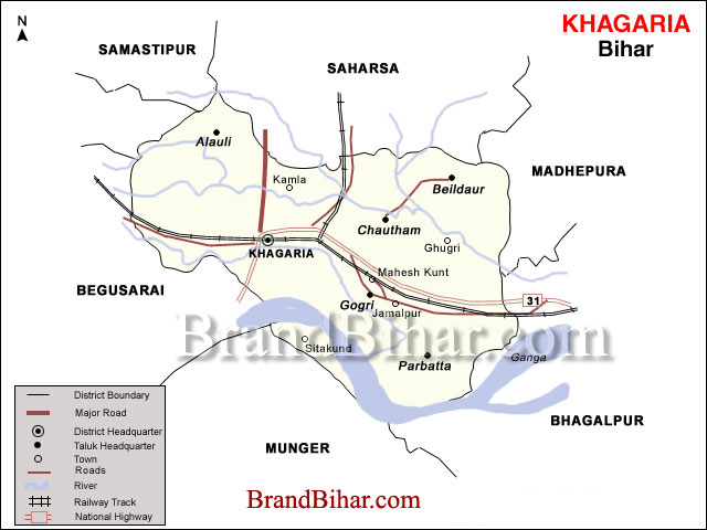
Total Sub-division 2
Total Blocks and Circle 7
Total Panchayats 129
Total Halka 61
Total urban Localities 2
Total Revenue Villages 306
Roads
National highways
(1) National Highways-( Barouni – Assam Road) In Khagaria District Nanku Mandal tola to Satishnagar Parwatta upto 48 K.M
(2) Natinal Highways-107 - In Khagria District Maheshkhut to Mali chowk upto 21 Km
Khagaria to Alouli- PWD road 18 Km
Khagaria to Bakhari- PWD road 15 Km
Khagaria to Son Manki- PWD road 2 Km
Maheshkhut to Aguwani Ghat- PWD road 30 Km
Mansi to Badla Ghat- REO 10 Km
Pasaraha to Maraiya- REO 14 Km
Alouli To Bakhari- REO 10 Km
Pirnagara to Beldour- REO 8 Km
Zero Mile to Beldour- PWD road8 Km
Railways (East- Central Railways)
Broad-gauge line- Barouni- Katihar to Assam
Station in Khagaria District- Umeshnagar, Khagaria Junction, Mansi Junction,
Maheshkhut, Pasaraha
Meterguage line- Saharsa to Samastipur
Station in Khagaria district- Imli, Olapur, Khagaria, Mansi, Badlaghat, Dhamaraghat, Tejnarayan Halt.
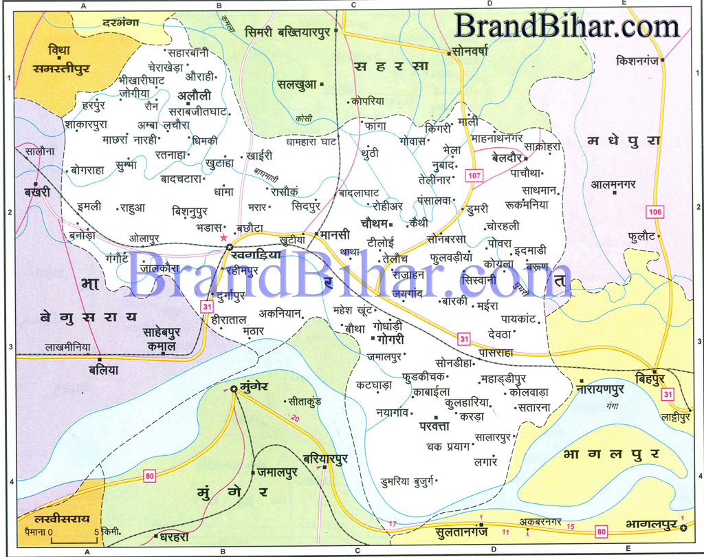
Click on the Map of Khagaria to see the large View of Khagaria Map
Before the construction of embankments along the Ganga, the Bagmati, the Burhi Gandak and the Kosi, namely karachi badlaghat embankment, Badla- Nagarpara embankment, Burhi Gandak protection embankment and Gogri- Narayanpur embankment, the vast tract of present Khagaria district was flat alluvial plain and was abound in marshy and swampy land. The characteristics of this part, north of the Ganga has been described as follows by a former collector of Munger, Mr. E. Lockwood in "Natural History, Sports and Travel"- "The northern part is an extensive plain formed by the rich alluvial soil brought down by the ever changing river. In the north, nine tenths of the trees are cultivated mangoes, whilst wheat, Indian corn, various kinds of millet peas, masur, rahar, oats, indigo, mustard, linseed and Casteor oil, are the principal crops which the land holders find profitable to grow." He further describes that in contrast, "the southern portion (south of the Ganga) consists of vast rice tracts and forests, which cover the metamorphic hills extending far away into central India from the town of Monghyr. In the forest of the south are found the ebony tree, the sal and the mahua. The south also yields vast quantities of rice,and a hundred and fifty tons of opium, grown on twenty five thousand acres of land, whilst, after crossing the Ganges, little rice and not a single poppy will be seen."
The major part of the alluvial plain comprising this district, at present, is mainly a saucer- shaped depression, the center of which was innundated during the rains by the over flow of the rivers and for the rest of the year was full of marshy hollows. The inundation has decreased after construction of embankments but still a large part in the north eastern part of the district, contained in west by Gogari- Maheshkhunt – Saharsa Road, in the north by the Koshi and in the south by the Ganga is completely inundated during rainy season except for the National Highway and the New Delhi – Gauhati Railway line .
River System:
The principal rivers of the district are the Ganga, the Burhi Gandak, the Bagmati, the Kamla and the Ghaghri (the mainstream of Koshi). The Ganga forms the southern boundary of the district in its entire length. This river has severe shifting tendencies resulting in a vast tract of diara land, on the northern side and several hamlets of the present Munger district have resettled on the north of the Ganga due to erosion caused by the shifting of the river. Due to vast tract of diara land, during rainy season, at some places, the breadth of the river runs into miles.
The Burhi Gandak, runs a Zig-Zag course through the district of Begusarai and enters Khagaria for a short while, running by the side of the town of Khagaria, and flows in to the Ganga. It forms the western boundary of the Khagaria town and a protection embankment built along the eastern side of this river, protects Khagaria town from the floods of Burhi Gandak.
The Bagmati enters the district from the western side, through the district of Begusarai. It then pursues a winding but generally easterly direction, till it flows into the Tilijuga or the Kamla near Chautham.
The Tilijuga or the Kamla enters the district from Darbhnga, near Mohraghat, It then flows south east to Chautham, merges into the Bagmati, and the united stream flows into the district of Bhagalpur under the name of the Ghaghri, which is known as one of the main branches of the Koshi.
Climate, the flora and the fauna
The climate of the district may be said to form a medium between the dry, parching heat of the up country and the close moist atmosphere of the south valley of Bengal. The heat is often intense but is very favourable during the rains because of law humidity. The seasons are the same as in the other parts of Bihar. The summer begins towards the middle of march and continues upto the end of June, when the rainy season begins, The months of April and May combine heat with high humidity relieved by intermittent rain falls. The rainy season continues upto October , while the water logging due to rain water continues in some areas up to the end of December. The winters are quite pleasant in this area.
In contrast to the southern portions of the old district of Munger, this district, lying north to the Ganga does not comprise of any forest of Sal or other large trees. However ever growing jungles of Kash and Pater is found in the northern areas in the belt of the Koshi and its tributaries .At most of the places, there are luxuriant gardens of mango and litchi, for which this district is mostly famous. Apart from these, Babul, Neem,Sirish and Sisho are also found. Not the least valuable product is thatching grass.It is grown on low land subject to inundation which retains water too long to enable the villagers to sow a cold weather crop upon it.
Wild animals, such as boars were occasionally found in the northern area bu now they are scarcely seen. However, birds are seen in large numbers in the various chours, particularly, in the area visited by the Koshi, the Kamla and the Bagmati. Snakes are also found in the river basins in a large number. Fish are abundant because of the rivers and the chours. Rohu, Kabai and Tengra are particularly known. During the winters, migratory birds come in large numbers in the northern part of the district.
Land use pattern -
In the whole district, there is no hill and no mineral is found in this district. As far as the land use pattern is concerned, wheat is the prominent rabi crop in the district. Due to floods and water logging, the paddy production is very low, except in the southern part of the district. Maize is grown abundantly almost through out the district, while banana cultivation as a cash crop, has grown into prominence in last two decades. Banana cultivation is done mostly in Choutham, Gogari and Parvatta blocks.
Apart from these mango and litchi orchards are abundant in this district and are found almost through out the entire area. The study of old gazetteers show that these orchards have been in existence since long.
As per the reports compiled by the Directorate of Statistics, Government of Bihar, the principal characteristics of the land use pattern of Khagaria district for the year 1998-99 is as follows:
Total Area - 1,49,342 Hectares. Total irrigated land: 87147 Hect.
Forest area : Nil Kharif paddy: 15618 Hect.
Total sown area : 88,140 Hectares. Garama paddy : 441 Hect.
Orchrd etc. area: 2732 Hectares. Wheat : 31584 Hect.
Water area- (i) permanent : 7715 Hect. Garama and rabbi maize:31636 Hct
(ii) Seasonal : 4272 Hect. Kharif maize: 503 Hect.
Wasteland and non-arable area : 13694 Hect.
Irrigation facilities :
After independence, the government has tried to create irrigation facilities through state tubewells and lift irrigation schemes. There are around 150 state tubewells and 20 lift irrigation schemes but 75 percent of the tubewells and 80 percent of the lift irrigation schemes are non-functional because of poor maintenance. Despite the abundance of rivers in the district, there does not exist any system of canal irrigation. As a result, the cultivators are dependent on the use of private borings fitted with pump sets. Fortunately, due to high water table in the area, the cost of boring is not very high and even middle class farmers can afford to have private boring and pumpsets. Agriculture, being the mainstay of the economy of the district, Government sponsored financing programmes, also give importance to bank financing of individual owned irrigation projects, comprising mainly of 5-7.5 KVA pumpsets and boring. To improve the functioning of the state owned tube wells, The Government has taken a decision to transfer thr ownership and maintenance of the tube wells to groups of beneficiaries and this is under the process of implementation in this district.
Industrialisation :
The economy of the district is dependent entirely on agriculture and its two main allied activities, namely horticulture and dairy. Industrialisation is completely absent. This district has potential for agro- based industries because of large production of banana and maize, but so far no industry has come-up. The development of Barauni district of Begusarai, as a prominent industrial area , has also pre-empted any industrialization in this district as entrepreneurs move towards Barauni or to the upcoming town of Silliguri in West Bengal, rather than investing in this district. Another reason is lack of surplus capital in this district because of historical reasons, as mentioned earlier. Agriculture was never so profitable here, as to generate surplus capital. Small business is the only non agricultural economic activity in this district.
Transport:
This district is well connected to other parts of Bihar and the country through railways as well as roads. New Delhi – Gauhati railway lines passes through Khagaria. Other prominent stations are Mansi, Maheshkhunt and Pasraha. From Mansi, one branch line goes towards Saharsa, while from Khagaria, one branch line goes towards Samastipur. Both these branch lines are still meter- gauge. Between Khagaria and Mansi, both broad gauge and meter gauge railway lines run parallel. Mansi had been an important place from the point of view of railways, since it used to be the headquarters of an Engineering district of railway but now most of important offices of railways have shifted from this place to other places, and mostly to Khagaria or Barauni, which falls in Begusarai district.
National Highway No. 31 passes through the district almost parallel to the railway line in west-east direction, the intersection of the two existing at a place called Chukati, eight kms. eastward from Khagaria. Almost 46 Km. of NH- 31 falls within the jurisdiction of Khagaria district. NH-31 goes right upto Gauhati and is an important road link of Bihar to the north – eastern part of the country and to Northern Bengal. From Maheshkhunt, on NH-31, branches off one road to Saharsa district. It is maintained by Road Construction Department of Government of Bihar.
Apart from National highway, the condition of other roads in the district is not very good. Historically also the situation had been the same. Excessive rains and water logging coupled with poor maintenance account for this. Prominent roads of the district, which are maintained by Road Construction department are Maheshkhunt- Chautham- Beldaur Road (26 Km.), Maheshkhunt – Gogari- Parvatta- sultanganj ghat Road (32 Km.), Khagaria- Alauli Road (18 Km.), Khagaria – Parihara- Bakhri Road (19 Km.), Khagaria-Munger ghat Road (6.5 Km.) , Khagaria- Sonmankhi Road (6.5 Km.) and Pansalwa – Baijnathpur Road (11 Km.).
The condition of other roads, some maintained by Rural Engineering organisation and some by Block and Panchayats are also worse . Due to existence of several rivers and rivulets, all weather communication in the interiors of the district would require huge investment in bridges and culverts, the lack of which makes large part of country side accessible by boats only during the rainy season.
The district of khagaria is unfortunate in the sense that very little has been recorded regarding the social and cultural history of this area.Whatever account of the old district of Munger has been unearthed,covers mainly the southern Munger and to some extent Northwest Munger,i.e.,the present Begusarai district. All the ancient remains and inscriptions have been discovered south of the Ganga, and some in Northwest, namely in Jaimanglagarh (Begusarai). Description of cultural heritage of old district of Munger, in contemporary literature, is found both in the writings of Bengali and English writers. Munger finds reference in the book "Tirtha Mangal" by the Bengali poet Vijaya Ram Sen Visharad, in the poetic work "Surodhani kabya" by Dinbandhu Mitra, the great dramatist of Bengal. Besides description of Munger is found in the works of famous Bengali poets Navin chandra Sen, Baldeo palit and great novelists Bankim Chandra Chaterjee, Ramesh chandra Dutta, Sarat chandra Chatterjee, Prabhat kumar Mukhopadhyay, Dwarka Nath Vidyabhusan, Nirupama Devi, Anand Shanker Ray, Saradindu Bandopadhayay, Bibhuti Bhushan Mukherjee etc.
Among the accounts of foreigners, the earliest account is that by Hiuen - Tsang in seventh century A.D., in which he describes Munger as "Hiranya Paurato". Buchanan Hamilton, the great medico-geographer, who had been deputed by the British government to compile a historical and geographical account of the country, had visited Monghyr in the first decade of the nineteenth century, and has given an account. Bishop Heber, who visited Munger in 1823, has given an account of Munger, in chapter 10 of his book "Narrative of his journey through the upper provinces in India".Emily Eden visited Munger in November1857 and left an account in the book "Up the Country". Description of Munger is also found in the book "Wanderings of a Pilgrim" by Fanny Parkes, who visited Munger in 1836; and in the book "Natural History, sport and Travel"- a book by Edward Lockwood, a former Magistrate of Munger.
Specific to the account of the area now coverd under Khagaria district, the 1960 Gazetteer says, "There is absolutely no literature on palm leaves nor there is any record to that effect. ………No record of any paintings has been found". Some of the contemporary literatures, however, cover the area of this district as well.
Some important events during the freedom struggle, is commonly told by the freedom fighters of this area. Some freedom fighters have recorded it in writings also in their memoirs and autobiographies. One of these is an event of 24th August 1942.That day three Englishmen were surveying the railwayline by plane when their plane fell in river near Rohiyar Bangaliya, which is presently under Chautham Block .The villagers, killed all three out of revenge. Getting the information, the then collector of Munger started repressive actions and killed several villagers.
Another important event is the martyrdom of Prabhu Nrayan Singh, who was killed by the bullets of Englishmen on 13th August 1942,while leading a proccession towards Khagaria police station. He belonged to a village called Marar, nearly five kms. from Khagaria town.
Mahendra Choudhary, of Pipra village in Choutham block is another martyr, remembered reverently in Khagaria. He was hanged to death on 6th August 1945 in Bhagalpur Central Jail. It is said that Mahatma Gandhi had corresponded with Viceroy Wavell for granting pardon to Mahendra Choudhary.
It is said that several important national leaders of freedom movement had visited and stayed in Khagaria, especially in Gogri and Parvatta. Important centres of freedom movement were Shyamlal National High school, founded in 1910, at Khagaria; Gogri and Nayagaon village in Parvatta .
Culturally, this district has tradition of Melas, usually held on the occassion of Hindu religious festivals, particularly in Dussehara and Kalipuja .Old tradition of mela continues in Katyani Asthan, a place in Choutham Block. Another old traditional mela is Gopastami Mela, held just after chhath in the month of Kartik, near Goshala, Khagaria. This Mela still continues to be held at the same place and same time.
It has been mentioned in the Gazetter of 1960, that an Agricultural and Industrial Exhibition was organised with help of the non-official gentlemen of Khagaria, sometime in the month of November 1952, to spread awareness about modern methods of agricultural and small industries. The 10 days long exhibition was formally inaugurated by the then Chief Minister of Bihar, and several government departments like Public Health, Agriculture, Veterinary, Silk Institute of Bhagalpur, Jail Department of Bhagalpur and Munger, Fishery, Cottage Industries, agriculture section of Sabour etc. participated in the exhibition. It was repeated in 1953, on a bigger scale , for about a fortnight. The exhibition was formally opened by the Finance Minister, Shri Anugrah Narain Singh and was visited by the Chief Minister Dr. S.K. Sinha and Irrigation Minister, Shri Ram Charitra Singh. These exhibitions served very useful purpose in not only disseminating knowledge but also in providing light entertainments to the general masses visiting the exhibition.
No important social or cultural event of the recent past was found recorded. However, everybody remembers the devastating floods of the year 1987, when even Khagaria town was heavily flooded, including collectorate and other government offices. Though floods have become an annual occurrence since times imemorial, but the floods of 1987 left a devastating trail, after a long time, especially after the major embankments were constructed.
Katyayani Asthan:
9; 9; Katyayani Asthan is situated at distance of approximately 12 kms. From the District headquaters, on the bank of river Koshi, between the stations Badlaghat and Dhamaraghat , which are stations on Mansi-Saharsa metergauge rail line. Temples of Ma Katyayani , as well as of Ram, Lakshman and Ma Janaki is situated at this place. Every Monday and Friday , large number of devotees come to this place for offering puja. As per the local folk traditions, Ma Katyayani is worshiped in two forms in this area. Some devotees worship Ma Katyayani as Sidh Peeth, while a large number of devotees worshiped as Lok Devi- Devi of Milk Cattles. That is why devotees offer raw milk to the deity.
It is said that Rishi Katyayan was performing Tapasya on the bank of river Kaushiki(now Koshi) when Ma Durga- the deity of Shakti took ‘avtar’ in child form and was accepted by Rishi as his daughter. Hence she is called Katyayani. Another story says that around 300 years ago, this place used to be dense forest. One day a devotee Shripat Maharaj saw Ma Katyayani in dream and as per her directions constructed an earthen Temple at that place and started worshiping her. In the year 1951, the temple was reconstructed. Lack of proper communication and the inaccessibility of the place by road has hampered the development of this area.
Shyamlal National High School:
This high school was established in 1910. Late Shri Shyamlal donated his entire property and formed a trust board under inspiration from Dr. Rajendra Prasad and Dr. S.K. Sinha. The students and teacher of this school played a very important role in the freedom movement. The school used to be a meeting ground of the Krantikaris.
Ajgaibinath Mahadeo :
This place though currently, in Sultanganj of Bhagalpur district, is very near to Aguanighat of Khagaria district and the temple of Lord Shiva on a hillock has traditionally been a centre of attraction for devotees. The importance of this place situated on the bank of river Ganga, stems from the fact, that Ganga flows northwards(Uttarayan) at this place and devotees after taking bath at this place, lift the Ganga water in ‘Kanwar’ for offering to Baba Baidyanath in Deoghar, covering a distance of around 105 Kms on foot. The 1960 Gazetteer describes this temple in Parbatta thana.
 <
<
Bihar became the first state in India to have separate web page for every city and village in the state on its website www.brandbihar.com (Now www.brandbharat.com)
See the record in Limca Book of Records 2012 on Page No. 217