Sheikhpura
Geography of Sheikhpura
Sheikhpura district came into existence on the 31st July 1994. Sheikhpura district is a part of Munger Division.Sheikhpura was separated from Munger District and was made a separate district with headquarters at Sheikhpura on the 31st July 1994.
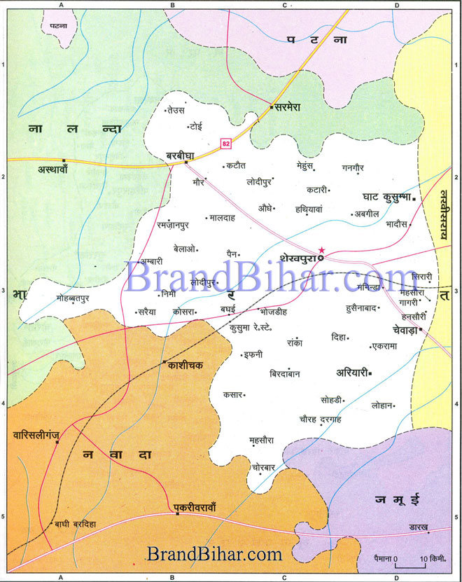
Click on the Map of sheikhpura to see the large View of sheikhpura Map
Date of Formation of Sheikhpura 31.07.1994 (Carved out of erstwhile Munger district)
Area of Sheikhpura 77,705 Hectares
Latitude of Sheikhpura 24’45” North to 25’ North
Longitude of Sheikhpura 85’45” East to 86’45” East
Boundaries of Sheikhpura
North - Nalanda & Patna district
South - Nawada & Jamui district
East - Lakhisarai district
West - Nalanda & Nawada district
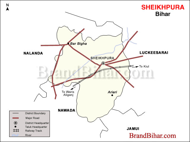
District Head Quarter Sheikhpura is situated at North side of Gaya-Kuel Rail line. This district lies in the southern part of Bihar that is bounded by Nalanda & Patna district in North, Nawada & Jamui district in South, Lakhisarai district in East and Nalanda & Nawada district in West. The district spanning in 77705 hectares is situated between North latitudes 24º45’ and 25º and East longitude 85º45’ and 86º45’.
Topography of Sheikhpura
Topographically district has two types of region – the rocky highland formed by hilly portion in centre, surrounded by fertile land in North, South, East and West. The land is sloping towards North Eastern side. Because of the low lying area in some parts of the North Eastern side, the water gets accumulated during rainy season leading to water-logged conditions. This area is geographically known as Tal area.
Climate of Sheikhpura
The district has hot summers & moderate winters. Summers start from middle of March and lasts till July. The monsoon usually breaks in the second half of June and lasts till September.
Soil of Sheikhpura
The district has rich alluvial soil composed of sand, silt and clay in most parts of district. The soil is most fertile and suitable for agriculture. The alkaline and saline deposits are rarely found.
Rivers in Sheikhpura
There are no big rivers of perennial nature worth to be mentioned in this district. Of course there are some small rivers which flow during rainy season viz Somi, Korihari, Tati, Kachchi & Rijown.
Area of Sheikhpura 689 km²
Population of Sheikhpura (2001) 5,25,137
Males Population of Sheikhpura 2,73,468
Females Population of Sheikhpura 2,51,669
Population density of Sheikhpura 762 Per Sq. K.M.
Sex Ratio in Sheikhpura 920
Literacy Rate in Sheikhpura 49.01%
Police Stations in Sheikhpura 19
Railway Police Stations in Sheikhpura 2
Panchayets in Sheikhpura 54
STD Code of Sheikhpura 06431
Culture of Sheikhpura
Cuisine of Sheikhpura
Places of interest in Sheikhpura
Events in Sheikhpura

|
