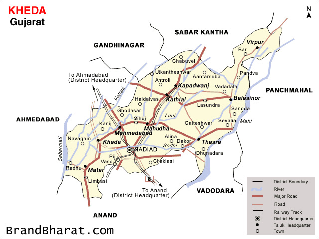

Kheda, also known as ‘Kaira’ is located 35 km1: District Map of Kheda with Talukas Ahmedabad on the bank of river Vatrak Kheda district borders with Sabarkantha district in the north, Panchmahals district in the east, Vadodara district in the south, and Ahmedabad district in the west. The district has 13 talukas with Nadiad (district headquarter), Mahemdabad, Kapadwanj, Matar, and Kheda being the developed talukas.
. Fact File 72.32º to 73.37º East (Longitude) Geographical Location 22.30º to 23.18º North (Latitude) 41º Centigrade (Maximum) Temperature 14º Centigrade (Minimum) Average Rainfall 723 mm Rivers 9 (Mahi, Sabarmati, Mesvo, Khari, Luni, Vatrak, Shedhi, Mahor, Varasi) Area 3959 sq. km District Headquarter Nadiad Talukas 10 Population 20,23,354 (As per 2001 Census) Population Density 480 Persons per sq. km Sex Ratio 922 Females per 1000 Males Literacy Rate 72.71% Languages Gujarati, Hindi and English Seismic Zone Zone III Source: Kheda District profile Booklet 2006-07 .
Dakor houses a temple of Lord Ranchodrai, a form of Krishna. The temple town of Vadtal, Bochasan & Nadiad comes within this district. Famous pilgrimage destinations in the district are Dakor temple, Santram temple, and Mahadev temple • Virpur • Kapadvanj.
The thermal power station at Wanakbori in Kheda with • Kathlal • Balasinor a total installed capacity of 1,470 MW is the largest • Mahemdabad coal-based thermal power station in the State • Kheda • Mahudha • Thasra. Focus sectors include Agriculture, Mineral-based • Matar • Nadiad District industries, Plastics, Engineering and IT sector Headquarter Talukas


Bihar became the first state in India to have separate web page for every city and village in the state on its website www.brandbihar.com (Now www.brandbharat.com)
See the record in Limca Book of Records 2012 on Page No. 217