
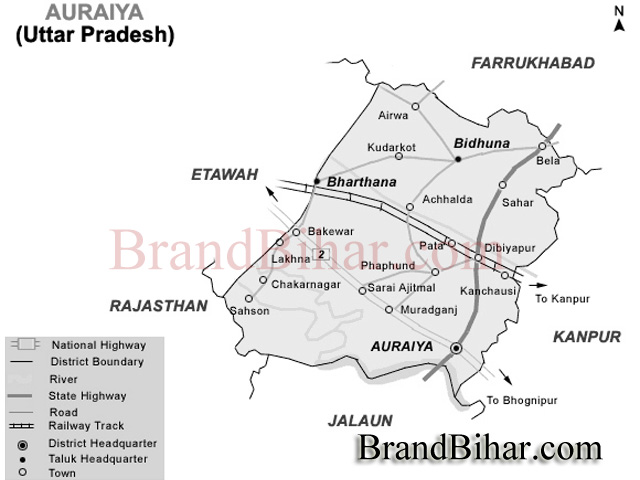
The district of Auraiya lies in the southwestern portion of Uttar Pradesh 26’ 21" and 27’ 01" north latitude and 78’ 45" and 79’ 45" east longitude and forms a part of the Kanpur Division. It is bounded on the north by the districts of Kannauj, western border adjoins tehsil Bharthana of the Etawah district and the district of Gwalior. The eastern frontier marches with the district of Kanpur Dehat, and along the south lie Jalaun. The total area according to the statistics of 1991-92 is calculated to be 2054 square kilometer.
Auraiya lies entirely in the Gangeticplain, but its physical features vary considerably and are determined by the rivers which cross it. The area of Etawah and Auraiya districts is divisible into four portions of district natural characteristics. The first of these consists of the country lying north-east of the Senger river, which runs across it from west to east almost parallel to the Yamuna; it includes the northern portions of tahsils Etawah and Bharthana. The second tract lies south of the Senger and extends as far as the high lands immediately overlooking the Yamuna. It comprises a slightly undulating switch of country covering portions of Etawah and Bharthana and the bulk of a Auraiya Tehsil of Auraiya District. The tract includes the parts of some tehsils that adjoins the river Yamuna. Beyond the Yamuna, stretching from the borders of tahsil Bah in Agra to the confluence of the Sindh, Kuwari, Chambal and Yamuna rivers, lies the high and broken country formerly known as Janibrast. These tracts differ from each other in a very marked degree though each presents general conformity within its own limits.
The portion of the Auraiya and Etawah districts jointly lying north of the Yamuna presents no great changes of level. It may be described as a plain intersected by shallow river valleys formed by small streams such as the Ahneya, Sengar and Rind, sloping from north-west to south-eat. A line of levels taken north and south across the district, two miles south-east of Hardoi in Etawah tahsil, shows that the recorded height above the sea near the village of Karri on the Mainpuri border is 191 feet near the Sarai Bhopat station of the East Indian Railway on the road from Etawah to Jaswantngar. The bed of the Sengar lies just 20 feet below this, the recorded level being 171 feet. The Etawah branch of the canal runs along the centre of this tract and the levels along it will give a clear idea of the south-easterly slope. At Hardoi the recorded height is 50053 feet; near Bharthana it is 482.00 feet; at Chachund 474 feet; and near Kanchausi, on the Kanpur border, 459 feet. The heights in the trans-Yamuna tract are not recorded, but this portion of the district lies at a somewhat higher elevation. The country, however, is too narrow and broken in character for transverse sections to convey an adequate idea of its general contour: the slope follows that of the rest of the district and is from north-west to south-east.
In the Pachar and Ghar tracts the soils are broadly distinguishable into dumat or loam, matiyar or clay, and bhur or sand. Besides these are found everywhere low-lying beds of clay in which water collects during the rains and rice alone can be grown; these clay beds are known as Jhabar. In the Kurka and trans-Yamuna tract several other classes of soil are met with. In the ravines of the river and the land immediately adjacent to them are found fields full of kankar and gravel, the soil of which is called Pakar; this is in fact a sandy soil mixed with gravel. Below the ravines and in the wider valleys between them the soil that is flooded by the Yamuna is called kachhar; and along the edges of the streams there is a rich strip of alluvial deposit which is known as Tir. Both kachhar and tir vary greatly in quality: some patches of these soils consist of a rich reddish clay which lets at a high rental; other portions are composed of a dark colored loam; and others again are while and sandy in appearance and less fertile.
The Yamuna
The Yamuna first touches the frontier of the district at the village of Bawat in the north-west of tahsil Etawah. For 24 Km. it forms the boundary between the district and Agra and then continues in a winding course, with a south-easterly direction, till it describes a remarkable curve near the village of Harauli before it unites its waters with those of the Chambal at Bhareh. Rain forced at this point by the latter stream it turns abruptly to the south and then once more sweeps eastward. Thenceforward its course lies almost due east, and it forms the common boundary of this district and Jalaun. The total length of the Yamuna in the district is about 112 Km. The bank on one side is unusually steep and precipitous whilst on other it is low and upon to the overflow of the river in the rains. For this reason the river spreads much in times of flood, and the surface velocity being small it covers a large area with a rich alluvial deposit in the rains. This natural tendency of the Yamuna to undulate the land along its banks is increased by the action of its tributary, the Chambal which rushing into it almost at right angles, throws lack by its greater volume and velocity the waters of the Yamuna and acts for the time as a sort of weir which still further retards that river.
The Chambal
South of the Yamuna flows the large river of the Chambal; this rises in Malwa on the northern slope of the Vindhyas near Mhow. It first touches the district at the village of Murong in the trans-Yamuna tract of Etawah tahsil, and for 40 Kms. forms the boundary of the district with the state of Madhya Pradesh. At Barechcha it is for the first time flanked on either side by land belonging to this district and for the remainder of its course of 35 Kms. flows through this district. Near its confluence with the Yamuna at Bhareh it forms a large though less abrupt curve than that river. In appearance and character the Chambal closely resembles the Yamuna and has within this district, a channel of equal dimensions. It is exceedingly liable to sudden and heavy floods owing to the step gradient of its bed before it debouches on the alluvial plain, and from the superior velocity of its stream, it discharges a greater volume of water than the Yamuna. Its waters are remarkable for their crystal-like clearness, and even after the two ricers have united the water of the Chambal may for some distance be distinguished from that of the Yamuna, which always carries either sand or mud in suspension. The Chambal seldom overdoes its banks. Both descriptions of land are sandy and the stream is too swine to allow of the deposit of fertilizing silt; consequently the alluvial patches along the Chambal are of much smaller extent and value than those along the Yamuna.
The Kuwari
This river is also the tributary of the Yamuna. This forms the district boundary with state of Madhya Pradesh for some 16 Kms. and for a like distance flows through the district till it unites with the Yamuna some 8 Kms. below the junction of that river with the Chambal. Rising in Madhya Pradesh not far from the old town of Morar, it flows north-west, north-east turns east and finally south-east, almost in a semi-circle, till it is joined by the Sindh in the extreme south of tahsil Auraiya. The Sindh which joins it, and sometimes gives its name to the short length of the united stream which joins the Yamuna differs in no way from it. Both, like the Chambal, are subject to great and sudden freshets during the rains, though they dwindle to insignificant streams in the hot season.
The vast stretch of the land from the confluence of Yamuna and Chambal upto the confluence of Sindh and Yamuna locally known as Pachnada, presents an extensive view Sylvan beauty during the rainy season and also in the winters. But it turns into an arid expanse during the summers.
The Sengar and Sirsa
It enters Etawah near the village of Dhanuha in the north of Etawah tahsil, and after traversing the district in a south-easterly direction, parallel to the Yamuna, passes into Kanpur district. In the upper part of its course the stream is not of much importance; its sides are low and shelving and its banks generally culturable. But at Amritpur, some 6 Kms. north of the town of Etawah, it is joined by the Sirsa, which up to this point bad shown a slight tendency to converge towards it. Thence forward the Sengar runs in a deep bad, and the drainage from the surrounding country tears its banks into ravines, which are only insignificant in comparison with the yawning fissures that disfigures the banks of the Yamuna. These ravines increase in extent and wildness as the river proceeds eaastward: they are altogether unfit for cultivation, but in places afford useful pasturage and produce Babul or Rionj trees, which are valuable for timber and bark. The Sirsa, which is merely a branch of the Sengar that separates near Umargarh in Jalesar, enters Etawah 17 Kms. west of the Sengar, and flows in a well defined channel to its junction with that stream, but it is of a small size.
The Rind and Arind
The river rises in Aligarh district and enters Etawah first at the village of Bhankhera in the north-east border of tahsil Bidhuna. After running along the district boundry for about 11 Km. in a tortuous course, it turns sharply southwards at Sabhad and meanders in a south easterly direction through Bidhuna till it finally passes into Kanpur. The Rind has a perennial stream, which shrinks considerably in size in the hot weather. At the village of Lakhna, where its course is more decidely deflected to east, it is joined by two tributaries known as Ahneya and Puraha.
The Ahneya and Puraha
These take rise in a series of lakes, the former near Kakan and the latter near Sauj in the Mainpuri district and little more than the drainage channels for carrying off superflous rain water. In the hot or cold season they are normally dry but in rains the Puraha, owing to its sinous course, injures a considerable amount of land on either bank.
Pandu
It is the only stream of the Etawah district which flows into the Ganga. It rises in the extreme north-east of Bidhuna tahsil in a large clay depression forming a lake lying between Sabhad and Nurpur. It flows eastwards into the Farrukhabad district.
Lakes and Jhils
The general excellence of the natural drainage afforded by the rivers and their tributary streams and watercourses over the bulk of the district is exemplified by the general rarity of lakes and marshes. Here the existence of clay beds in hollows has rendered conditions favorable for the extensive. Those that they exist are situated for the most part on the borders of the district, especially in tahsil Bidhuna, where they lie somewhat beyond the influence of the natural drainage lines or of the artificial cuts made in connection with the canals. The most important of these Jhils are those at Durmangadpur, Mundai, Hardoi, Barauli, Auton, Yakubpur, Tirhwa, Dhupkari or Thulpia and Manaura in tehsil Bidhuna.
Waste Land of Auraiya district, Uttar Pradesh
The average area returned as barren waste for the year ending in 1998 was 8221 Hectares. This also consists either of Usar plains, in which the soil is rendered sterile by the saline efflorescence known as Reh or else of ravine jungle. This however, excludes the area under water and also the land occupied by sites, roads and the like amounting to 16949 Hectares.
Rainfall
The average annual rainfall in the district is 792 mm and in the year 1998 Zila Sankhikiya Patrika it is given to be 738 mm. About 85% of the annual normal rainfall in the district is received during the south west mansoon months from June to September, August being the rainiest month.
Temperature of Auraiya district, Uttar Pradesh
After February there is a steady increase in temperature. May is generally the hottest month with the mean daily maximum temperature at about 42°C and the mean daily minimum at about 26°C. The nights are warmer in June than in May. The heat in the summer is intense and the hot, dry and dust-laden westerly winds which are common in the hot season make the weather severely trying. In this season maximum temperatures on individual days sometimes reach 46°C or over. With the onset of the south-west mansoon over the district by about the third week of June there is appreciable drop in the day temperature and the weather becomes more bearable. But the nights still continue to be as warm as in the latter part of the summer. With the with drawl of the mansoon by about the end of September there is a slight increase in the day temperature. There is a rapid drop in the night temperature after the with drawl of the mansoon. After November both day and night temperatures decrease rapidly till January, which is usually the coldest month with the mean daily maximum temperature about 23°C and the mean daily minimum temperature at about 8°C. During the cold season the district as affected by cold waves and fog and the minimum temperature occasionally goes down to 3°C.
Humidity of Auraiya district, Uttar Pradesh
During the rainy season the relative humidity is generally high being over 70%. Thereafter the humidity decreases and by summer which is the driest part of the year the relative humidities in the afternoons become less than 30%.
Winds of Auraiya district, Uttar Pradesh
Winds are generally light and are mostly from directions between south-west and north-west. In May, the south-west mansoon season winds on many days blows also from directions between north-east and south-east.
Cultivable Land
Forest land, groves, land prepared for sugar-cane furrows, waste-lands like pastures and grazing land often classified as unculturable due to excess of sand or reh or on account of ravine-scouring or overgrowth of dhak constitutes cultivable land in the district. The area of cultivable land in the district in 1990-91 was 141624 hectares. According to the 1990-91 agricultural survey, the total number of active cultivable lands remained to be 151838. Most of the cultivables are small. The count of cultivables less than 0.5 hectares remained to be 47.65%, and between 0.5 & 1.0 hectares the culivables remained to be 23.76%, and 1.0 to 2.0, it were 17.33%, and 2.0 to 4.0 hectare cultivable land's percentage was 8.54%, and more than 4.0 it were 2.72%.
Multiple Cropping and Rotation of Crops
The practice of growing more than one crop simultaneously in a single field in a single season gives additional harvest. Thus, this practice increases the over all yield and ensures maximum use of the soil and nutrients. If there is danger of loss to any crop due to adverse weather conditions or diseases, there are some better chances for the other crop in the field if the system of multiple cropping is adopted, arhar is almost always sown with bajra, urd or moong, jowar, ground nut, linseed wheat with gram, pea or mustard, barley with gram or peas or both. Potato is generally mixed with methi or onion. The importance of rotation of crops has been fully realised by the farmers of the district. Scientific rotation of crops helps the farmers to maintain the fertility of the fields by growing exhaustive crops in rotation with restorative crops. As such this practice is generally prevalent through out the whole cultivated area of the district and it has its root in the minds of every cultivator. A particular crop sown in one season restricts the cultivator to sow the other crop in the next season, which is most beneficial for the field and by this practice the turnout also is enhanced to some extent. The practice of green-manuring during kharif is also popular before sowing wheat in Rabi.
The popular rotations followed in the district are Paddy Wheat, Paddy Gram, Paddy Peas, Paddy Berseem, Maize Wheat, Maize Potato-wheat, Bajra Wheat or Peas or Gram or Peas and Gram, on account of being leguminous crops, have restorative qualities, Cultivation of these crops in rotation with exhaustive crops like paddy and bajra helps to maintain the fertility of the fields. The old practice of growing wheat after a fallow period is being replaced by growing wheat after green manuring in Rabi.
Sugar-cane is generally sown in three years rotation. The areas, near the help of organic manures and fertilizer. In such areas three to four crops in a year are taken such as maize, early potato, late potato and Sitaphal. In these areas the fertility of the fields is maintained by full manuring.
Means of Irrigation
Auraiya is an agriculture land. The main occupation in the district is agriculture. Thus, the means of irrigation keeps the important role on such lands. To become independent in the production of cereals it is neccessary to provide the sufficient means of irrigation in the cultivable lands so that the crops giving more production could be harvested by increasing the agriculture density.
In earlier times the district was almost wholly dependent on wells and, to a small extent, on tanks. The well-irrigation appears to have been largely replaced by canals. The chief sources of irrigation are wells, tanks.
Agriculture
Harvests
The methods of cultivation in this district are generally the same as those found elsewhere in the Doab. The application of manure and the use of water for irrigation are extensively resorted to. There are the usual harvests known as the Kharif or autumn, the Rabi or spring and Zaid or extra harvest. The Kharif crops are shown in Ashadha- Sravana and reaped in Kuar-Kartika after the cessation of rains usually well before the preparation of fields for the Rabi sowings which begin in October-November i.e. Kartika and Agrahanya and are harvested in March-April and even May. The Zaid consists of vegetables and low grade cereals sown in March or April and reaped before June. The system of double cropping is followed to a considerable extent in the district owning to the facilities for irrigation. The figures of dofasli area for the different tahsils do not exhibit any great variations, but the proportions are highest in Bidhuna and Bharthana and the proportion is lowest in Auraiya.
The Uttar Pradesh Petrochemical Complex(UPPC) of Gas Authority of India Limited is located at Pata, Distt. Auraiya, U.P. It was set up in accordance with GAIL’s mission to maximise the value addition from each fraction of Natural Gas.
Pricipal Crops
Kharif Crops
The chief Kharif crops are the millets, known as Bajra and Jowar, paddy and maize. These are sown either alone or in combination with Arhar. Bajra is chiefly grown in light and sandy soil. Between 1903 and 1907 Bajra alone or in combination covered 42.511 ha. or 28.47 per cent of the kharif. In the subsequent year its cultivation in the district increased by nearly 12,900ha. In 1380 Fasli year that is 1973-74 the bajra covered an area of 77.673 ha. Jowar is generally grown in the stiffer and better soils but like bajra it is usually mixed with arhar, the proportion grown alone being only 5per cent. Both Bajra and Jowar are usually sown in June on unirrigated land,the fields being previously prepared by ploughing. They are reaped in November. A considerable amount of Jowar is grown only for fodder especially in Etawah and Bharthana tahsils. Another important Kharif crop is rice. There has been an enormous increase in the extent of rice cultivation during the last hundred years. Several local varieties of rice are grown. In 1973-74 (1380 Fasli year) the area covered by paddy was 2,59,506 ha. The only other Kharif crop that is of any importance is maize which during the period between 1903 and 1907 covered on the average 52.321 acres or 14.18 per cent of the area cultivated in the kharif. The only tahsil however, where it is extensively planted is Bidhuna. Maize is usually sown in the best gauhani dumat soil, close to the village site, where the fields yield two crops a year. The land is generally well manured and the crops are sown asearly as possible in Asharh. During the ensuing month the field is carefully weeded and by the middle of Bhadon the plants usually attain a height of four feet and the ears begin to show. Among the Kharif cereals small pulses known as Moth, Urd and Moong, the small millet Mandua, and Hemp or Sanai were largely grown in the past, but new incentives in the field of agriculture have lowered their popularity and more valuable crops like paddy, maize and sugar-cane are gradually replacing them. In 1997-98 the production of pulses was 21977 metric tonnes and by sugar-cane was 80647 Metric tonnes.
Rabi Crops
Wheat heads the list of Rabi cereals in the district in point of area, which in 1973-74 constituted more than half of the total Rabi sowing. Wheat is grown pure as well as mixed with crops like barley and gram. Wheat when mixed with gram is known as gochani and with barley as gujai. The area under pure wheat has no doubt increased during recent years, but the old practice or sowing mixed crops, a characteristic feature of the district has not disappeared altogether. The wheat crop requires a good soil, and an assured supply of water besides manure. In 1380 Fasli year wheat covered an area of 95,860 hact.
Barley alone or in combination with gram forming the mixed called bejhar to which peas are generally added was the favourite rabi staple in the past, in the area sown with it is due to their replacement with wheat and its combination. Barley flourishes even in soils and in tracts which are not suited to wheat cultivation for lack of irrigation facilities.
Gram is, on the whole, little irrigated and it resists drought well, and for this reason it is acceptable to the inhabitants of the par. It can be grown on inferior soils. It needs only two ploughings and does not usually require manure. The only other Rabi staple which needs mention is peas.
Cash Crops
Sugar-cane, oil seeds like ground-nut, linseed and rape-seed, vegetables and fruits, hemps, tobacco, sweet potato, condiments and spices are the main non-food crops of the district. Vegetables though they occupy a small area in the district specially around the towns and large villages, constitute valuable crops. The kharif vegetables comprise Lady-fingers, Gourds, Spinach, Brinjal etc., and those of Rabi comprise Cauliflowers, Cabbage, Tomatoes, Potatoes, Rradishes, Brinjal and T turnip etc.
In the past indigo was also grown in the district, but totally disappeared in time with the coming in of synthetic dyes. In the past, opium was an important non-food crop.
Poppy can only be grown on the best irrigated and manured gauhan land, and calls for a considerable amount of skill and capital.
Soil Nutrients
Cattle dung, farm refuse and stable little are the common manures used by the farmers. After soil test in district Etawah it has been realised that the soils are generally deficient in Nitrogen, Phosphate and Pottasium in different degree, which is removed by the use of chemical fertilizers, green manure and compost. The green manure crops like sanai, dhaincha and moong provide natural nitrogenerus ingredients to the soil and increase its fertility. The chemical fertilizers, though costly, have also become popular among the cultivators. Among chemical fertilizers used by the farmers of the district are the urea, amonium sulphate, calcium, amonium nitrate, diamonium phosphate, amonium phosphate, super phosphate and N.P.K. The chemical fertilizers are obtained through agriculture and co-operative seed stores and agents of Agro Industrial Corporation besides individual dealers.
Banking -
The region covered by the present district of Auraiya had flourishing trade with the adjoining regions, represented by the present district of Farrukhabad, Mainpuri, Agra, Gwalior and Kanpur, since early times. Trade was huge when law and order prevailed and tended to decrease sharply in chaotic conditions. Although there was a lack of means of communications trade was carried on horses, ponies, and boats which sailed on the rivers Yamuna and Chambal. Chambal was mostly used by the trader to cross over to Bhind and Gwalior in the south of the district, while Yamuna was extensively used for trade with Delhi and Agra in the west and Kalpi and Allahabad in the east. As far back as the fifth and sixth centuries B.C. wealth was hoarded in brazen jars or in houses. Usury was frowned upon even when indulged in by members of traditional high castes though the Vaishyas charged more than the prescribed rates of interest. In the mediaeval period particularly in the reign of Akbar and his two successors, trade was flourishing and the money was available with the rich and affluent. Auraiya being situated between Agra and Allahabad was an important centre of trade for agricultural commodities, ghi and handloom cloth.
There was a government treasury at Auraiya and a few sub treasuries at important places like Phaphund and Auraiya. The treasuries served as government banking institution for the collection of government dues, and for incurring expenditure on behalf of the government. The British established their own treasury at Auraiya after 1801, on taking the administration of the district.
In the beginning of the twentieth century there were a number of firms that advanced money. In large transactions, when valuables such as jewellery were deposited with the lender as security, the rate of interest varied from 6 to 12 per cent per annum, according to the proportion that the value of the property deposited bore to the sum advanced to the debtor. For loans advanced on personal security only, the interest charged was higher, the average being 18 per cent per annum.
Trade and Commerce -
In the last 35 years of the nineteenth century, the railway was the main artery of communication. East Indian Railway was easily accessible to every portion of the district. The chief exports were cotton, ghi, oil-seeds and imports-piece goods, metals, rice salt and sugar. Even ghi and wheat from adjacent areas of Gwalior were diverted to the railway stations in the district for export. The pattern of trade in the twentieth century was the same export of ghi, cotton, and other agricultural goods and import of cloth general merchandise, cotton-yarn and machinery.
However by the thirties, the growing of cotton declined sharply and by fifties there was no cultivation of cotton in the district. With the development of roads, the pace of trade has increased and besides the railway a large number of trucks operate in the district. The road to Bhind and Madhya Pradesh has been bridged and now there is a continuous flow of goods and passenger traffic on his road. Ghi and food-grains are the main commodities of trade. Ghi is transported to as far as Punjab in the west. Bengal in the east and Andhra Pradesh, Tamilnadu and Bombay in south and south-west. Wheat is the main food-grain which is transported to the adjoining districts from the wholesale markets of the district.
The other important commodities of internal and external trade are gram, paddy, pulses and oil-seeds. The production of handloom cloth has also increased since 1972-73. Auraiya, Etawah and Jaswantnagar are the main trade centres of handloom cloth. Fish is available in the rivers and lakes of both the districts in large quantities. Fish is sent to Delhi, Bihar and Bengal.
In 1974, there were 1279 km. of metalled roads in the district, which connect the various trade centres in the district and also link them with the adjoining districts and states. There are 3 railway stations and the Northern Railway runs for a total length of about 70 Km. in the district. The infrastructure of the district thus adds to the increasing trade. Approximately 58,830 persons were employed in trade and commerce in 1990 in Etawah and Auraiya districts jointly. There were 537 licensed traders in the district(Auraiya and Etawah jointly) in 1990-91 and about 260 commission agents also earned their livelihood from trade and commerce.
Small Scale Industries -
Auraiya district is one of the backward districts in industrial sector declared by the government of Uttar Pradesh state. Only the two town areas, Diviyapur and Auraiya, are equipped with main industries. The Rice-mills and Dal-mills are working well there in these two areas. Other than these mills some steel furniture and cement products small scale industries are there in Auraiya district located at different places. The raw material for these small scale industries is imported from Agra and Kanpur.
There are least facilities in the district to sale the products off and so the sale is mainly dependent on the districts nearby. Mainly, the rice, pulses and desi ghee is exported at large scale to the other districts and states.
In the Auraiya city itself the wooden furniture work is on large scale and due to its cost and quality factor, the furniture has made a good place in the market of nearby districts.
GAIL -
The Gas Authority of India Ltd. (GAIL), one of India's leading Public Sector Enterprises, is the largest gas transmission and marketing company in the Country. The Company, possessing a well developed and efficient infrastructure, was established as a wholly owned Company of the Government of India in August, 1984 with 100% equity held by the Goverment of India and, within a short time, it has grown into one of the 'Navratna'enterprises and is ranked among the top ten companies in India.
The Uttar Pradesh Petrochemical Complex(UPPC) of Gas Authority of India Limited is located at Pata, Distt. Auraiya, U.P. It was set up in accordance with GAIL’s mission to maximise the value addition from each fraction of Natural Gas.
Language and Script-
The language of practically the entire population is what is known as western Hindi. The returns of the census 1981 showed that this language was spoken by about 96.8 per cent of the population. In 1971, the percentage of Hindi speaking persons was 96.4. Western Hindi is split up into several subdivisions. In 1981, the language known as Hindustani or Urdu was spoken by about 3.10 per cent (3.35 per cent in 1961) of the people, representing for the most part the inhabitants of Etawah city, while the bulk of the people spoke Antarbedi, or its varient called Pachharua, so called after the tract of that name. In the trans-Yamuna portion of the district the dialect is known as Bhadauri, which is a form of Bundelkhandi, itself a branch of Hindi. It derives its name from Bhadawar, the home of the Bhadoria Rajputs. A few people also speak Punjabi, Bengali or Sindhi. Devannagri script is being used for Hindi and its allied branches such as Garhwali, Kumauni etc. and the script used for Urdu is Persian. The other languages generally using their own scripts.
Religion and Caste -
In 1991, Hindus percentage was 92.79% against the state average of 83.76% and 6.63% of Musalims as compared to the state average of 15.48%. The remaining 0.58% of the district population was comprised of Sikhs, Christians, Jains and Buddhists.
Festivals and Fairs
Hindu Festivals
The series of festivals commence with Sheetla Ashtmi, which falls on the 8th day of the first fortnight of Chaitra, the first month of the Hindu calender, when goddess Sheetla is worshipped. The 9th day of the bright fortnight of that month is called Ram Navmi, when the birthday of Lord Rama is celebrated with great rejoicings and fairs are held at Lakhna and other places. The 10th day of the latter half of Jyaistha is called the Ganga or Jeth Dasahra, when the Hindus take a bath in the river. Nag Panchami falls on the 5th day of the bright half of Sravana, when the Nagas or serpent gods are worshiped by offering of milk, flowers and rice. On Raksha Bandhan, which falls on 15th day of bright half of the same month, rakhis (thread symbolising protection) are tied by sisters around the right wrist of their brothers and by Brahmana priests to their patrons. Janmashtmi is observed on the 8th day of the dark half of Bhadra to commemorate the birth anniversary of Lord Krishna. The 30th day of Asvina is the Pitra Visarjan Amavasya, when manes are propitiated.
The worship of Durga is continued for nine day during the bright half of Asvina, known as Nav-Ratri and the 9th day of that is known as Durga Naumi. The next day is Dasahra or Vijaya Dashmi, dedicated to the worship of goddess Vijaya, also commemorating the victory of Rama over Ravana. The Ramlila celebrations are held at various places in the district. The 4th day of the bright half of Kartika is called Karva Chauth, when married women keep fast for the well-being of their husbands. Deepawali falls on the last day of the dark fortnight of Kartika, but festivities start two days earlier with Dhan Teras, celebrated as the birth day of Dhanvantri, the divine physician. On the main day of the festival every Hindu house is illuminated and the goddess Lakshmi is worshipped. On the third day of Deepawali, after Goverdhan and Chitragupta or Dawait puja, Bhaiya Dweej is celebrated when ladies put Roli mark (tika) on the forehead of their brothers. On the 8th day of bright half of that month, the Gopasthmi is celebrated when the cow is worshipped. A big bathing festival is organised on Kartika Puranmashi, the full moon day, when people take a bath in the river and fairs are held at different places in the district. The Sakat Chauth falls on the 4th day of the dark half of Magha when the male children cut the figure of a goat made of til and their mothers keep fasts.
A fast observed and the temples of Shiva are specially decorated. For the Arya Samajists, Shivaratri is a memorable day because Dayananda, the son of a devotee of Shiva and the founder of this school got enlightenment on this night. They celebrate the week preceding this day as Rishi-bodha-saptah and arrange discourses by learned scholars for the seven days.
About sixty fairs, big and small, are held annually in the district. Most of the festivals are accompanied by local fairs too. Of these, the exhibition and cattle fair of Etawah is the most important. They are attended by about 2,00,000 persons and heads of cattle sold number between 10,000 and 15,000.
Muslim Festivals -
They celebrate almost all the important festivals, but the number of their festivals is limited. The important ones are being given below. Their festivals start with the Ashra (Muharram), which falls on the 10th day of Muharram. The first ten days of the month of Muharram are devoted to commemorate the martyrdom of Imam Husain, the grandson of the Prophet of Islam and His companions on the battle field of Karbala, and are particularly observed as a mourning period by the Shias. On Ashra, the last of the ten days being the most important one, when Imam Husain was killed, the tazias are taken out in procession for burial at Karbala. Chehlum, on the 20th of Safar, failing on the 40th day from Ashra, usually marks the end of the period of moukrning. On the 12th of the month of Rabi-ul-Awwal falls Barawafat mwhich marks the birthday of Prophet Muhammad, when alms art distributed amd discourses on His life and missions are hedld. Shabe-barat the 14th day of Shaban, is a festival of rwejoicing marking the birth of the 12th Imam. It is celebrated by a display of fireworks, distribution of sweets, and fatiha prayers for the peace of the souls of departed ones. Ramzan is the month of fasting and on its expirty i.e. on visibility of the moon the festival of Id-ul-fitar is celebrated on Shawwal Ist by offering namaz in Idgahs and mosques, and exchanging gifts and greetings. The Id-ul-Zuha their last festival, is celebrated on the 10th of the month of Zilhij, to commemorate the occasion when Prophet Ibrahim resolved to treat his son Ismail as an offering to mark the highest form of the sacrificial spirit which was blessed by God the mercifulo who rewarded him by not busting Ismail and having a sheep to sanctify the altar instead. The Muslims say their namaz (community prayers) in Idgahs and sacrifice sheep and goats. The typical feature of these two festivals is the eating of sewain.
Sikh Festivals -
The important festivals of Shikhs are the birthdays of Guru Nanak Deva and Guru Govind Singh when processions are taken out, congregational prayers are held in gurdwaras and extract from the holy Granth are recited. Their festivals are Baisakhi and Lohri, local fairs are held at gurdwaras on each occasion.
Christian Festivals -
The important festivals of the Christians are Christmas, falling on December 25th, marking the birthday of Jesus Christ, Good Friday which commemorates his crucifixion, and Easter in memory of his resurection. New Year's Day (1st day of January) is also celebrated by them and the Christmas celebrations usually end with new year.
Jain Festivals -
They celebrate the birth and the nirvana anniversaries of the last Tirthankara, Mahavira, the former on the 13th day of the bright half of Chaitra and the latter on the Deepawali day. The Paryushan or the Dashalakshanaparva, during the last days of Kartika, Phalguna and Asadha are the periodical holy days when the devotees observe a fast and perform worship in temples.
Buddhist Festivals -
The prinipal festival of the Buddhists is the Buddha Purnima, celebrated on the last day of Vaisakha, which marks the birthday of Buddha as well as his nirvana.
Ornaments -
Men are not so fond of ornaments, sometime they wear a gold or silver ring on their finger, and a thin chain around the neck. Women, generally, adorn their wrists with churis (banglse) made of glass, silver or gold, anguthis (finger rings), necklaces, nose-ring, nose-pendent, nose-stud, ear-ring, payal, bichua (only maried women) waist girdle and the like. The poor people usually go in for silver ornaments and the rich have gold pieces sometimes studded with precious stones and pearls. The lust for heavy jewellery is, however, on the decline partly due to the high prices of gold and silver, and poartly because of social transformation and fear of loss.
The Uttar Pradesh Petrochemical Complex(UPPC) of Gas Authority of India Limited is located at Pata, Distt. Auraiya, U.P. It was set up in accordance with GAIL’s mission to maximise the value addition from each fraction of Natural Gas.
Dance and Music -
Popular varieties of folk music prevalent through out western U.P. e.g. the Allaha, Phaag, Kajari and Rasiyas, etc. are popular in this district as well, and are sung at different times of the year. Folk songs known as Dhola, Unchari and Langadia are also very common in the villages. Bhajans, Kirtan in a chorus to the accomplishment of musical instruments is very much liked by the inhabitants of the district.
A number of open air performances, combining the rural style of folk music and dancing with a central theme are a regular feature of rural life in the district. The dance named Banjasha is one of the most popular folk dances of villagers of the district. Nautankis and dramas based on mythology are often staged and attract large gatherings, particularly in the villages.
Dress -
The people of Auraiya have colorful and different attires. The Sari-blouse-petticoat trio is the most favourite dress of ladies of all denominations, though women in Dupatta-kurta-salwar combinations are usually met with.
The best known Auraiya outfit is the 'Sari'. This graceful attire is a rectangular piece of Cloth, normally 5 to 6 meters in length and over a meter in width. It is worn without any pins or buttons or fastenings. The tightly fitted short blouse worn under a sari draped over the wearer's shoulder, is known as the Pallav or palloo. The style, color and texture of a saree varies from one to another and may be made from cotton, silk or one of several man-made materials. Its ageless charm is provided from the fact that it is not cut or tailored for any particular size, and can fit any woman.
Another form of outfit supported by Indian women is known as Salwar-suit. Kurta is a long tunic worn over pyjama like trousers, drawn in at the waist and ankles, known as 'Salwar', or a tight fitting trouser known as 'Chudidaar'. This dress is popular among the Muslim and Punjabi ladies and unmarried Hindu girls. The collarless or mandarain collared kurta, can be worn over a chudidaar and is popular with both men and women.
The men in village use to wear the traditional attires like kurtas, lungis, dhotis and pyjama. The collerless Khadi (homespun cloth) jackets known as 'Nehru Jackets' are also popular. The muslim women wear the traditional all enveloping 'Burkha' and the men use to wear a round cap on their head.
Food of Auraiya, Uttar Pradesh - Wheat constitutes the staple food of the people, other materials commonly consumed here as food being maize, barley, gram and jowar. Chapaties prepared from kneaded wheat or corn flour are generally eaten with dal or gur and milk. The pulses consumed here are urd, arhar, moong, chana, masur etc. One major meal is taken at about 1 P.M. in the day. Breakfast consists of tea and any of the Indian or western stuff. At nightfall the people take a light meal. Among edible fats ghee, vanaspati and mustard oil are more commonly used. The pure ghee of Etawah is quite famous for its thickness and purity. Spicy diet is not preferred though people are quite fond of pickles, chutneys and bari-mangauris.
Phoolmati temple, Auraiya, Uttar Pradesh
Kali Mata Temple, Auraiya, Uttar Pradesh
sankat mochan mandir, Auraiya, Uttar Pradesh
Jai Maa Kali Mandir, Auraiya, Uttar Pradesh
Shitteshwar Mandir, Auraiya, Uttar Pradesh
santoshi mata temple narayanpur, Auraiya, Uttar Pradesh
Surya Palace, Auraiya, Uttar Pradesh
Swarn Cinema, Auraiya, Uttar Pradesh
shree krishna talkies, Auraiya, Uttar Pradesh
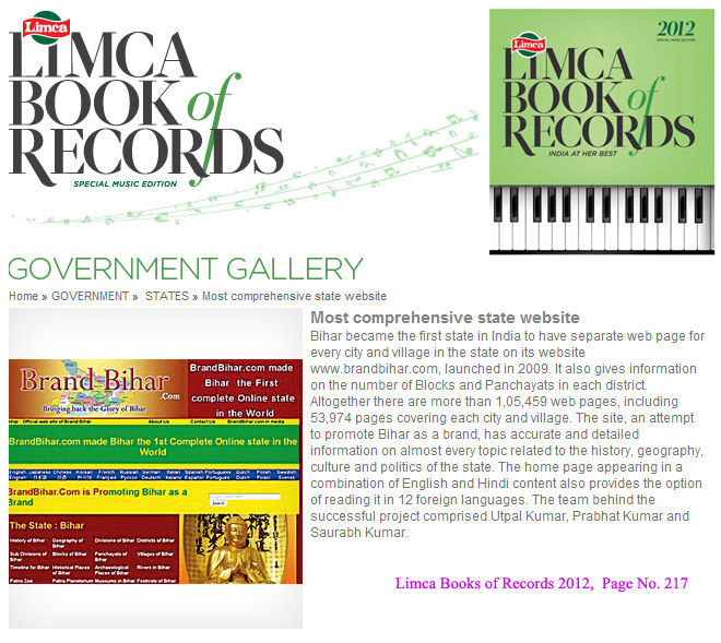
Bihar became the first state in India to have separate web page for every city and village in the state on its website www.brandbihar.com (Now www.brandbharat.com)
See the record in Limca Book of Records 2012 on Page No. 217