
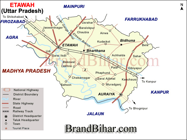
Etawah district lies in the southwestern portion of Uttar Pradesh 26° 47" north latitude and 72° 20" east longitude and forms a part of the Kanpur Division. In shape it is a parallelogram with a length from north to south 70 Km. and East to west 66 Km. on one side and 24 Km. on the other side. It is bounded on the north by the districts of Farrukhabad and Mainpuri, while the small extent of western border adjoins tahsil Bah of the Agra district. The eastern frontier marches with the district of Auraiya, and along the south lie Jalaun and the district of Gwalior, the division line being, except for a short distance, the Chambal and Yamuna rivers. The total area in 1999 is calculated to be 2434 Km.
Population -
The population of the district in the census of 1991 resulted to be 4242310 (Auraiya district's population included) with the density of about 946 persons per sq. km. The sex ratio is 816 females per 1000 males in rural area and 870 females per 1000 males in urban area.
Topography -
Etawah lies entirely in the Gangetic plain, but its physical features vary considerably and are determined by the rivers which cross it. It is divisible into four portions of district natural characteristics. The first of these consists of the country lying north-east of the Senger river, which runs across it from west to east almost parallel to the Yamuna; it includes the northern portions of tahsils Etawah and Bharthana. The second tract lies south of the Senger and extends as far as the high lands immediately overlooking the Yamuna. It comprises a slightly undulating switch of country covering portions of Etawah and Bharthana and the bulk of a Auraiya Tahsil (now in Auraiya District). The tract includes the parts of some tahsils that adjoins the river Yamuna. Beyond the Yamuna, stretching from the borders of tahsil Bah in Agra to the confluence of the Sindh, Kuwari, Chambal and Yamuna rivers, lies the high and broken country formerly known as Janibrast. These tracts differ from each other in a very marked degree though each presents general conformity within its own limits.
The Pachar
The northern portion of the district, which is separated from the rest by the Sengar, is known in the language of the country as Pachar. It presents a level expanse of upland, of which the surface is only broken by occasional sandy ridges or by one or two inconsiderable streams such as the Pandu and Arind orRind, and the latter's tributaries, the Ahneya and Puraha. The soil is for the most part a rich loam of great fertility, interspersed with large tracts of usar and frequently varied by beds of clay, the centers of which form marshes or jhils out of which rise some small streams. It forms the most important part of the district from an agricultural point of view and is thickly studded with well populated sites and hamlets.
The Ghar
The second tract between the Sengar and the Yamuna locally known as the Ghar. Its characteristic soil is a red a light but fertile sandy loam. The surface, which is not quite level, lies lowest nearly midway between the two rivers and one like the pachar, the Ghar is a plain of culturable soil unbroken by usar, while in the depressions the clay is found in much smaller beds. Here and there the ground rises into hillocks of sand and bhur, but these are for the most part confined to the Bharthana tehsil. Some of the largest towns in the district lie in this tract, in close proximity to the old Mughal road; yet the population is less dense and the village sites are smaller than in the northern portion of the district. The extension of canal irrigation to the Ghar, however, has considerably altered the characteristics of the tract and done much to assimilate in to the Pachar.
The Karka
South of the Ghar lie the uplands and ravines along the banks of the Yamuna and these form the third natural division of the district known as the Karka. The population here is scanty and the village sites are usually buried far away amid ravines; but the characteristics are not entirely uniform. If, a section of theKarka were taken from the uplands to the river, it would show first a tract of cultivated land similar in character and, as a rule, quite equal to the soil of theGhar, secondly, a large area of wild and deep ravines covered with grass and thorny brushwood and in parts quite bare; thirdly, a low-lying plain of rich soil, subject to the floods of the Yamuna where it overflows in the rains; and fourthly, a fringe or strip of rich alluvial deposit along the very edge of the stream. Sometimes, however, the two latter and most valuable portions are altogether wanting, and the river sweeps right up to the foot of other bluffs that terminate the ravine ground. In some places, especially to the cast of the district, where the broken ground is wildest and covers the largest area, the ravines do not run down evenly and directly to the river but are divided as it were into two stages or steps, the first being separated from the last by be uneven plain of rough clay not unlike Bundelkhand soil.
The Par
The fourth tract comprises the lands lying between the Yamuna and the Chambal known as Par, and those on the right bank of the Chambal between it and the Kunwari. It is divided into four portions, namely Patti Kamait, Taluqas Chakarnagar and Sahson, Taluqa Bhareh and Taluqa Sandaus; and includes portions of the three tahsils Auraiya, Bharthana and Etawah. It extends from the borders of tahsil Bah in the Agra district to the point where the Yamuna,Chambal, Sindh and Kuwari unite. Patti Kamait comprises the western portion lying within the Etawah tahsil and extends as for as Kandhesi Ghar in Bharthana tahsil. To the last, where the space between the rivers is narrowest, the ravines Join and leave no level around between them; but towards the west the streams separate and in the centre is found a fine tableland of good loam, some four or five miles wide. There are few ridges of sand, and where the rivers again trend towards each other the soil is a friable clay full of holes and fissures like the well known black soil of Bundelkhand. This upland is bordered on either side by a network of intricate ravine beyond which there exists but little alluvial land, though a few bays of white sandy kachhar soil are found on the Yamuna bank.
Soils -
In the Pachar and Ghar tracts the soils are broadly distinguishable into dumat or loam, matiyar or clay, and bhur or sand. Besides these are found everywhere low-lying beds of clay in which water collects during the rains and rice alone can be grown; these clay beds are known as Jhabar. In the Kurka and trans-Yamuna tract several other classes of soil are met with. In the ravines of the river and the land immediately adjacent to them are found fields full of kankar and gravel, the soil of which is called Pakar; this is in fact a sandy soil mixed with gravel. Below the ravines and in the wider valleys between them the soil that is flooded by the Yamuna is called kachhar; and along the edges of the streams there is a rich strip of alluvial deposit which is known as Tir. Both kachhar and tir vary greatly in quality: some patches of these soils consist of a rich reddish clay which lets at a high rental; other portions are composed of a dark colored loam; and others again are while and sandy in appearance and less fertile.
River System -
The rivers and streams of the district consist of the Yamuna its two large affluent, the Chambal and, the Kuwari; the Sengar, and its tributary Sirsa; The Rind or Arind and its tributeries the Ahenya, the Puraha and the Pandu.
The Yamuna
The Yamuna first touches the frontier of the district at the village of Bawat in the north-west of tahsil Etawah. For 24 Km. it forms the boundary between the district and Agra and then continues in a winding course, with a south-easterly direction, till it describes a remarkable curve near the village of Harauli before it unites its waters with those of the Chambal at Bhareh. Rain forced at this point by the latter stream it turns abruptly to the south and then once more sweeps eastward. Thenceforward its course lies almost due east, and it forms the common boundary of this district and Jalaun. The total length of the Yamuna in the district is about 112 Km. The bank on one side is unusually steep and precipitous whilst on other it is low and upon to the overflow of the river in the rains. For this reason the river spreads much in times of flood, and the surface velocity being small it covers a large area with a rich alluvial deposit in the rains. This natural tendency of the Yamuna to undulate the land along its banks is increased by the action of its tributary, the Chambal which rushing into it almost at right angles, throws lack by its greater volume and velocity the waters of the Yamuna and acts for the time as a sort of weir which still further retards that river.
The Chambal
South of the Yamuna flows the large river of the Chambal; this rises in Malwa on the northern slope of the Vindhyas near Mhow. It first touches the district at the village of Murong in the trans-Yamuna tract of Etawah tahsil, and for 40 Kms. forms the boundary of the district with the state of Madhya Pradesh. AtBarechcha it is for the first time flanked on either side by land belonging to this district and for the remainder of its course of 35 Kms. flows through this district. Near its confluence with the Yamuna at Bhareh it forms a large though less abrupt curve than that river. In appearance and character the Chambalclosely resembles the Yamuna and has within this district, a channel of equal dimensions. It is exceedingly liable to sudden and heavy floods owing to the step gradient of its bed before it debouches on the alluvial plain, and from the superior velocity of its stream, it discharges a greater volume of water than theYamuna. Its waters are remarkable for their crystal-like clearness, and even after the two ricers have united the water of the Chambal may for some distance be distinguished from that of the Yamuna, which always carries either sand or mud in suspension. The Chambal seldom overdoes its banks. Both descriptions of land are sandy and the stream is too swine to allow of the deposit of fertilizing silt; consequently the alluvial patches along the Chambal are of much smaller extent and value than those along the Yamuna.
The Kuwari
This river is also the tributary of the Yamuna. This forms the district boundary with state of Madhya Pradesh for some 16 Kms. and for a like distance flows through the district till it unites with the Yamuna some 8 Kms. below the junction of that river with the Chambal. Rising in Madhya Pradesh not far from the old town of Morar, it flows north-west, north-east turns east and finally south-east, almost in a semi-circle, till it is joined by the Sindh in the extreme south of tahsil Auraiya. The Sindh which joins it, and sometimes gives its name to the short length of the united stream which joins the Yamuna differs in no way from it. Both, like the Chambal, are subject to great and sudden freshets during the rains, though they dwindle to insignificant streams in the hot season.
The vast stretch of the land from the confluence of Yamuna and Chambal upto the confluence of Sindh and Yamuna locally known as Pachnada, presents an extensive view Sylvan beauty during the rainy season and also in the winters. But it turns into an arid expanse during the summers.
The Sengar and Sirsa
It enters Etawah near the village of Dhanuha in the north of Etawah tahsil, and after traversing the district in a south-easterly direction, parallel to the Yamuna, passes into Kanpur district. In the upper part of its course the stream is not of much importance; its sides are low and shelving and its banks generally culturable. But at Amritpur, some 6 Kms. north of the town of Etawah, it is joined by the Sirsa, which up to this point bad shown a slight tendency to converge towards it. Thence forward the Sengar runs in a deep bad, and the drainage from the surrounding country tears its banks into ravines, which are only insignificant in comparison with the yawning fissures that disfigures the banks of the Yamuna. These ravines increase in extent and wildness as the river proceeds eaastward: they are altogether unfit for cultivation, but in places afford useful pasturage and produce Babul or Rionj trees, which are valuable for timber and bark. The Sirsa, which is merely a branch of the Sengar that separates near Umargarh in Jalesar, enters Etawah 17 Kms. west of the Sengar, and flows in a well defined channel to its junction with that stream, but it is of a small size.
The Rind and Arind
The river rises in Aligarh district and enters Etawah first at the village of Bhankhera in the north-east border of tahsil Bidhuna. After running along the district boundry for about 11 Km. in a tortuous course, it turns sharply southwards at Sabhad and meanders in a south easterly direction through Bidhuna till it finally passes into Kanpur. The Rind has a perennial stream, which shrinks considerably in size in the hot weather. At the village of Lakhna, where its course is more decidely deflected to east, it is joined by two tributaries known as Ahneya and Puraha.
The Ahneya and Puraha
These take rise in a series of lakes, the former near Kakan and the latter near Sauj in the Mainpuri district and little more than the drainage channels for carrying off superflous rain water. In the hot or cold season they are normally dry but in rains the Puraha, owing to its sinous course, injures a considerable amount of land on either bank.
Pandu
It is the only stream of the Etawah district which flows into the Ganga. It rises in the extreme north-east of Bidhuna tahsil in a large clay depression forming a lake lying between Sabhad and Nurpur. It flows eastwards into the Farrukhabad district.
Lakes and Jhils -
The general excellence of the natural drainage afforded by the rivers and their tributary streams and watercourses over the bulk of the district is exemplified by the general rarity of lakes and marshes. The only portions that might be considered an exception to this rule are the northern portions of the district in tahsils Etawah, Bharthana and Bidhuna. Here the existence of clay beds in hollows has rendered conditions favorable for the extensive. Those that they exist are situated for the most part on the borders of the district, especially in tahsil Bidhuna, where they lie somewhat beyond the influence of the natural drainage lines or of the artificial cuts made in connection with the canals. The most important of these Jhils are those at Hardoi, Raan, Parauri and Baralokpur in tahsil Etawah; at Sarsainawar, Kunetha, Mahauri, Kudrel, Sonthna and Usarahar in tahsil Bharthana; and at Durmangadpur, Mundai, Hardoi, Barauli, Auton, Yakubpur, Tirhwa, Dhupkari or Thulpia and Manaura in tahsil Bidhuna the last five all lying close to the Farrukhabad boundary.
Waste Land -
The average area returned as barren waste for the five years ending in 1997 was 13435 Hectares or 56.98 per cent of the entire district. This also consists either of Usar plains, in which the soil is rendered sterile by the saline efflorescence known as Reh or else of ravine jungle. This however, excludes the area under water and also the land occupied by sites, roads and the like amounting to 18662 Hectares.
Climate
Rainfall
The average annual rainfall in the district is 792 mm and in the year 1998 Zila Sankhikiya Patrika it is given to be 640 mm. About 85% of the annual normal rainfall in the district is received during the south west mansoon months from June to September, August being the rainiest month.
Temperature
After February there is a steady increase in temperature. May is generally the hottest month with the mean daily maximum temperature at about 42 °C and the mean daily minimum at about 26 °C. The nights are warmer in June than in May. The heat in the summer is intense and the hot, dry and dust-laden westerly winds which are common in the hot season make the weather severely trying. In this season maximum temperatures on individual days sometimes reach 46 °C or over. With the onset of the south-west mansoon over the district by about the third week of June there is appreciable drop in the day temperature and the weather becomes more bearable. But the nights still continue to be as warm as in the latter part of the summer. With the with drawl of the mansoon by about the end of September there is a slight increase in the day temperature. There is a rapid drop in the night temperature after the with drawl of the mansoon. After November both day and night temperatures decrease rapidly till January, which is usually the coldest month with the mean daily maximum temperature about 23 °C and the mean daily minimum temperature at about 8 °C. During the cold season the district as affected by cold waves and fog and the minimum temperature occasionally goes down to 3 °C.
Humidity
During the rainy season the relative humidity is generally high being over 70%. Thereafter the humidity decreases and by summer which is the driest part of the year the relative humidities in the afternoons become less than 30%.
Winds
Winds are generally light and are mostly from directions between south-west and north-west. In May, the south-west mansoon season winds on many days blows also from directions between north-east and south-east.
Famous Things in Etawah -
Ghee and Food-grains - Ghee and food-grains are main commodities of trade in Etawah. Ghee id transported to as far as Punjab in the west, Bengal in the East and Andhra pradesh, Tamil nadu and Mumbai in South and South-West. Wheat and oils seeds are the main produce that is transported to the adjoining districts from Etawah's Wholesale Market
Buffalo and Goats District -Etawah is known for Jamuna pari goats & Bhadabari Buffalows.
Jamunapari Goats : This breed is world famous and in whole India it is found in Chakarnagar & Barhpura areas of Etawah.The main identity of this breed long ears,parrot like nose,long bodies,heavy feet and long hairs. This breed survives on Babul, Jherberi and green leaves for food. This breed produces milk better than any other breed. It produces on an average 3 litres milk per day. Due to these qualities this breed is liked by everyone. Due to its uncontrolled export this breed is now vanishing. U.P. Govt. has banned its export since 1976. Total no. of Goats is about 5660.
Bhadawari Buffalows: This breed is also found in Chakarnagar & Barhpura area. It is recognise due to its copper color and two or three white lines on its neck. Their milk contain around 13% fat. This much fat is not found in any other breed.
Potato : The potato is the main crop of the district and exported to the neighbouring districts and states also. In 2001-2002, it was grown on 30.92 Quintal per hectares of land.
Language and Script
The language of practically the entire poopulation is what is known as western Hindi. The returns of the census 1981 showed that this language was spoken by about 96.8 per cent of the population. In 1971, the percentage of Hindi speaking persons was 96.4. Western Hindi is split up into several subdivisions. In 1981, the language known as Hindustani or Urdu was spoken by about 3.10 per cent (3.35 per cent in 1961) of the people, representing for the most part the inhabitants of Etawah city, while the bulk of the people spoke Antarbedi, or its varient called Pachharua, so called after the tract of that name. In the trans-Yamuna portion of the district the dialect is known as Bhadauri, which is a form of Bundelkhandi, itself a branch of Hindi. It derives its name from Bhadawar, the home of the Bhadoria Rajputs. A few people also speak Punjabi, Bengali or Sindhi. Devannagri script is being used for Hindi and its allied branches such as Garhwali, Kumauni etc. and the script used for Urdu is Persian. The other languages generally using their own scripts.
Religion and Caste
In 1991, Hindus percentage was 92.79% against the state average of 83.76% and 6.63% of Muslims as compared to the state average of 15.48%. The remaining 0.58% of the district population was comprised of Sikhs, Christians, Jains and Buddhists.
Hindu
The major community was originally divided into four branches, Brahmana, Kshatriya, Vaishya and Sudra. This ancient division was mainly occupational but gradually developed into a hereditary order. Now in modern society, due to the impact of progressive social and economic forces, the old cast structure is crumbling though somewhat slowly. It has already lost its rigidity. There are several social groups like Kayasths, Gujars etc. present for this community.
Hindu castes.
According to the returns of the last census the Hindu population of the district was composed of representatives of 69 different castes, while in the case of 39 persons no caste was specified. Only a few of these however, are of any great importance. There are five castes with over 50,000 members apiece together accounting for 56.39 per cent of the Hindu inhabitants: six others occur in numbers exceeding 20,000 making up 17.87 per cent and 8 more are represented by over 10,000 souls, an additional 12.32 per cent. The remainder, 13.42 per cent in all, comprises persons belonging to a great variety of castes, the majority of which are common to all parts of the the country and are not specially noticeable.Scheduled Caste/Harijans
First in point of numbers among the Hindu castes of the district come Scheduled Caste/Harijans, of whom in 1991 there were 5,31,885 forming 12.5 percent of the Hindu population. Their numbers are almost equally divided among the five tahsil of the district and there is nothing particular to note concerning them. As elsewhere, they occupy almost the lowest place in the social scale and form the bulk of the labouring population.Ahirs
The second place is held by Ahirs with 102,698 representatives or 13.56 of the Hindu population. Like Scheduled Caste/Harijans they are very equally divided in all tahsils, but are a litle more numerous in Etawah than elsewhere. Neither Nandbans nor Gwalabans Ahirs are numerous, and other subdivisions are very scantily represented. Ahir occupy a considerable amount of land as tenants, and are found much scattered in hamlets on outlying lands, where they have a readier access to the available pasture grounds in the village. As cultivators they can, on the whole, rank on an equality with Brahmans and Rajputs, but fall far behind Kachhis and Lodhis.Brahmans
Third on the list come Brahmans, of whom in 1991 there were 96,943 or 12.77 percent of the Hindus. They are considerably more numerous in Bharthana and considerably less numerous in Bidhuna than in the other tahsils. Throughout the district,they belong chiefly to the Kanaujia division. Most of the Kanaujia Brahmans are of the Dube family. One celeberated member of this family, by name Sheo Nath, is said to have accompanied the Chauhans in their first immigration to Etawah under Sumer Sah. There does not appear to have been any great clan movement into this district on the part of the Kanaujias. The ancestors of the present families came in by degrees as the purohits of the conquering tribes, and, after first obtaining grants of land for subsistence, gradually accumulated considerable possessions. Under the Government of the Nawab Wazur the old hereditary landholders were often glad to allow their purohits to act for them in their dealings with the amils of the Oudh court. This system was continued under British rule with the result that Brahmans became recorded as proprietors of countless estates to the total disregard of the claims of those who had held possession of them for six hundred years. The Kanaujia houses of Lakhna and Dalipnagar are said to be descended from Dhan and Man, who came into the district from Nandhana in the Kanpur district in the sixteenth century.Rajputs
Next to Brahmans come Rajputs, of whom in 1991 there were 69,050 representatives, forming 9.12 percent of the Hindu population. They are most numerous in Bharthana tahsil, and fewest in Bidhuna. At last settlement they held as much as 34.83 percent of the total area as landlords, even exceeding Brahmans; while as tenants their holdings fell somewhat short of that caste. There are one or two large Rajput proprietors, but their villages are generally held in copareenary tenure, and as cultivators they are indifferent.Chauhan
First in point of number these clans is the Chauhan. In 1991 they numbered 11,134 persons, scattered over all tahsils, but considerably more numerous in Bharthana tahsil, and to a less extent, Etawah, than elsewhere. Tradition makes Sumer Shah, the fourth in descent from Prithviraj of Delhi, their leader at the time of their migration to Etawah; and their first acquisitions were wrested from the Meos. As the colony progressed it is said to have taken possessions of the whole country from Chhibramau in Farrukhabad to the Yamuna, including 1,162 villages. Aat all events from an early date the Chauhans colonised the western portion of the district, leaving a debateable land bedtween themselves and the Sengars, which their Brahman dependants soon occupied. From this stock is sprung the Raja of Partabner, the Chakarnagar and Sakrauli families who lost their estates for rebellion, and the former Raos of Jasohan and Kishni, who have sunk into the position of petty zamindars.Sengars
The Sengars, who number 7,201 persons, are probably the earliest Rajput settlers in the district. Their stronghold is Bidhuna and in Etawah their numbers are insignificant. The Sengars claim descent from one Singi or Sringi Rishi ( so called from a horn which he had on his forehead), a Brahman, who married the daughter of a Gaharwar Raja of Kanauj. From one of his sons came the Gautams of Argal in Fatehpur, and to another, Padam, the Sengars trace their origin.
Muslim
The majority of Muslims in the district belong to the Sunni sect. Among them the most numerous are the Sheiks. Their main subdivisions represented here are the Qurreshis and Siddiqis and most of them are residing in Etawah tahsil. Pathans are more evenly distributed than Sheiks, but like them are more numerous in Etawah than in the other tahsils; they belong for the most part to the Gori, Lodi and Yasufzai clans. The remaining Muslim subdivisions, mostly occupational are the Darzi, Hajjam, Dhobi, Qassab, Faqir, Lohar and Bhisti etc.
Sikh
In 1971, there were 1,766 Sikhs in the district, of whom 928 were males and 838 famales, residing mainly in urban areas and only 428 in the rural areas. They constitute 0.12 per cent. of the district population.
Christian
In 1991, there were 301 Christians of whom 201 were residing in urban areas. They constitute only 0.01 per cent of the district population.
Jain
They numbered 3610 in 1991, with 3087 residing in urban areas and share 0.17% of the total population. They are usually called Saraogis.
Buddhist
In 1991, they numbered 5659 of whom 5510 were of them were residing in rural areas. They constitute about 0.27 percent of the district population.
Dress
The people of Etawah have colorful and different attires. The Sari-blouse-petticoat trio is the most favourite dress of ladies of all denominations, though women in Dupatta-kurta-salwar combinations are usually met with.
The best known Etawah's outfit is the 'Sari'. This graceful attire is a rectangular piece of Cloth, normally 5 to 6 meters in length and over a meter in width. It is worn without any pins or buttons or fastenings. The tightly fitted short blouse worn under a sari draped over the wearer's shoulder, is known as the Pallav or palloo. The style, color and texture of a saree varies from one to another and may be made from cotton, silk or one of several man-made materials. Its ageless charm is provided from the fact that it is not cut or tailored for any particular size, and can fit any woman.
Another form of outfit supported by Indian women is known as Salwar-suit. Kurta is a long tunic worn over pyjama like trousers, drawn in at the waist and ankles, known as 'Salwar', or a tight fitting trouser known as 'Chudidaar'. This dress is popular among the Muslim and Punjabi ladies and unmarried Hindu girls. The collarless or mandarain collared kurta, can be worn over a chudidaar and is popular with both men and women.
The men in village use to wear the traditional attires like kurtas, lungis, dhotis and pyjama. The collerless Khadi (homespun cloth) jackets known as 'Nehru Jackets' are popular also popular. The muslim women wear the traditional all enveloping 'Burkha' and the men use to wear a round cap on their head.
Ornaments -
Men are not so fond of ornaments, sometime they wear a gold or silver ring on their finger, and a thin chain around the neck. Women, generally, adorn their wrists with churis (banglse) made of glass, silver or gold, anguthis (finger rings), necklaces, nose-ring, nose-pendent, nose-stud, ear-ring, payal, bichua (only maried women) waist girdle and the like. The poor people usually go in for silver ornaments and the rich have gold pieces sometimes studded with precious stones and pearls. The lust for heavy jewellery is, however, on the decline partly due to the high prices of gold and silver, and poartly because of social transformation and fear of loss.
Regional Music and Dance
Popular varieties of folk music prevalent through out western U.P. e.g. the Allaha, Phaag, Kajari and Rasiyas, etc. are popular in this district as well, and are sung at different times of the year. Folk songs known as Dhola, Unchari and Langadia are also very common in the villages. Bhajans, Kirtan in a chorus to the accomplishment of musical instruments is very much liked by the inhabitants of the district.
A number of open air performances, combining the rural style of folk music and dancing with a central theme are a regular feature of rural life in the district. The dance named Banjasha is one of the most popular folk dances of villagers of the district. Nautankis and dramas based on mythology are often staged and attract large gatherings, particularly in the villages.
Cuisine of Etawah, Uttar Pradesh
Wheat constitutes the staple food of the people, other materials commonly consumed here as food being maize, barley, gram and jowar. Chapaties prepared from kneaded wheat or corn flour are generally eaten with dal or gur and milk. The pulses consumed here are urd, arhar, moong, chana, masur etc. One major meal is taken at about 1 P.M. in the day. Breakfast consists of tea and any of the Indian or western stuff. At nightfall the people take a light meal. Among edible fats ghee, vanaspati and mustard oil are more commonly used. The pure ghee of Etawah is quite famous for its thickness and purity. Spicy diet is not preferred though people are quite fond of pickles, chutneys and bari-mangauris.
Doab or Level Alluvial Plain
The portion of the district lying north of the Yamuna presents no great changes of level. It may be described as a plain intersected by shallow river valleys formed by small streams such as the Ahneya, Sengar and Rind, sloping from north-west to south-eat. A line of levels taken north and south across the district, two miles south-east of Hardoi in Etawah tahsil, shows that the recorded height above the sea near the village of Karri on the Mainpuri border is 191 feet near the Sarai Bhopat station of the East Indian Railway on the road from Etawah to Jaswantngar. The bed of the Sengar lies just 20 feet below this, the recorded level being 171 feet. The Etawah branch of the canal runs along the centre of this tract and the levels along it will give a clear idea of the south-easterly slope. At Hardoi the recorded height is 50053 feet; near Bharthana it is 482.00 feet; at Chachund 474 feet; and near Kanchausi, on the Kanpur border, 459 feet. The heights in the trans-Yamuna tract are not recorded, but this portion of the district lies at a somewhat higher elevation. The country, however, is too narrow and broken in character for transverse sections to convey an adequate idea of its general contour: the slope follows that of the rest of the district and is from north-west to south-east.
Festivals and Fairs -
Hindu Festivals
The series of festivals commence with Sheetla Ashtmi, which falls on the 8th day of the first fortnight of Chaitra, the first month of the Hindu calender, when goddess Sheetla is worshipped. The 9th day of the bright fortnight of that month is called Ram Navmi, when the birthday of Lord Rama is celebrated with great rejoicings and fairs are held at Lakhna and other places. The 10th day of the latter half of Jyaistha is called the Ganga or Jeth Dasahra, when the Hindus take a bath in the river. Nag Panchami falls on the 5th day of the bright half of Sravana, when the Nagas or serpent gods are worshiped by offering of milk, flowers and rice. On Raksha Bandhan, which falls on 15th day of bright half of the same month, rakhis (thread symbolising protection) are tied by sisters around the right wrist of their brothers and by Brahmana priests to their patrons. Janmashtmi is observed on the 8th day of the dark half of Bhadra to commemorate the birth anniversary of Lord Krishna. The 30th day of Asvina is the Pitra Visarjan Amavasya, when manes are propitiated.
The worship of Durga is continued for nine day during the bright half of Asvina, known as Nav-Ratri and the 9th day of that is known as Durga Naumi. The next day is Dasahra or Vijaya Dashmi, dedicated to the worship of goddess Vijaya, also commemorating the victory of Rama over Ravana. The Ramlila celebrations are held at various places in the district. The 4th day of the bright half of Kartika is called Karva Chauth, when married women keep fast for the well-being of their husbands. Deepawali falls on the last day of the dark fortnight of Kartika, but festivities start two days earlier with Dhan Teras, celebrated as the birth day of Dhanvantri, the divine physician. On the main day of the festival every Hindu house is illuminated and the goddess Lakshmi is worshipped. On the third day of Deepawali, after Goverdhan and Chitragupta or Dawait puja, Bhaiya Dweej is celebrated when ladies put Roli mark (tika) on the forehead of their brothers. On the 8th day of bright half of that month, the Gopasthmi is celebrated when the cow is worshipped. A big bathing festival is organised on Kartika Puranmashi, the full moon day, when people take a bath in the river and fairs are held at different places in the district. The Sakat Chauth falls on the 4th day of the dark half of Magha when the male children cut the figure of a goat made of til and their mothers keep fasts.
The Makar Sankranti coincides with the transit of the sun from Dhanu to Makara and is celebrated as a bathing festivals and falls on the 11th day of dark fortnight of Magha. Vasant Panchami, which falls on the 5th day of the later fortnight of Magha, is devoted to the worship of Saraswati, the goddess of learning. Shivaratri is celebrated in honour of Lord Shiva's wedding and falls on the 13th day of the dark half of Phalguna. A fast observed and the temples of Shiva are specially decorated. For the Arya Samajists, Shivaratri is a memorable day because Dayananda, the son of a devotee of Shiva and the founder of this school got enlightenment on this night. They celebrate the week preceding this day as Rishi-bodha-saptah and arrange discourses by learned scholars for the seven days.
Holi is the concluding and important of festivals of Vikram Era falling on the last day of Phalguna, when bonfires are lighted on cross-roads at a fixed time, to commemorate the annihilation of all evil forces of the previous year represented by the demon god's sister Holika. The ears of the newly harvested barley are roasted in them to serve as on offering to the god. The most interesting feature of this festival is the squirting of coloured water and the rubbing of coloured powder (abir and gulal) in a frolicsome mood. On this occasion people exchange greetings by visiting the houses of their friends and relations. The rural inhabitants also sing phaags on dholak, the favourite songs of the season. This festival is gradually assuming the status of a national festival celebrated by all sections Sikhs, Muslims and Christians also participating except the very orthodox among them.
About sixty fairs, big and small, are held annually in the district. Most of the festivals are accompanied by local fairs too. Of these, the exhibition and cattle fair of Etawah is the most important. They are attended by about 2,00,000 persons and heads of cattle sold number between 10,000 and 15,000.
Muslim Festivals
They celebrate almost all the important festivals, but the number of their festivals is limited. The important ones are being given below. Their festivals start with the Ashra (Muharram), which falls on the 10th day of Muharram. The first ten days of the month of Muharram are devoted to commemorate the martyrdom of Imam Husain, the grandson of the Prophet of Islam and His companions on the battle field of Karbala, and are particularly observed as a mourning period by the Shias. On Ashra, the last of the ten days being the most important one, when Imam Husain was killed, the tazias are taken out in procession for burial at Karbala. Chehlum, on the 20th of Safar, failing on the 40th day from Ashra, usually marks the end of the period of moukrning. On the 12th of the month of Rabi-ul-Awwal falls Barawafat mwhich marks the birthday of Prophet Muhammad, when alms art distributed amd discourses on His life and missions are hedld. Shabe-barat the 14th day of Shaban, is a festival of rwejoicing marking the birth of the 12th Imam. It is celebrated by a display of fireworks, distribution of sweets, and fatiha prayers for the peace of the souls of departed ones. Ramzan is the month of fasting and on its expirty i.e. on visibility of the moon the festival of Id-ul-fitar is celebrated on Shawwal Ist by offering namaz in Idgahs and mosques, and exchanging gifts and greetings. The Id-ul-Zuha their last festival, is celebrated on the 10th of the month of Zilhij, to commemorate the occasion when Prophet Ibrahim resolved to treat his son Ismail as an offering to mark the highest form of the sacrificial spirit which was blessed by God the mercifulo who rewarded him by not busting Ismail and having a sheep to sanctify the altar instead. The Muslims say their namaz (community prayers) in Idgahs and sacrifice sheep and goats. The typical feature of these two festivals is the eating of sewain.
Their important fairs held in the district are the urs celebrations of some important pirs (Muslim saints), who flourished here at one time or the other. Among these, the urs performed at Karwa Buzurg village and Phaphund are of most importance.
Sikh Festivals
The important festivals of Shikhs are the birthdays of Guru Nanak Deva and Guru Govind Singh when processions are taken out, congregational prayers are held in gurdwaras and extract from the holy Granth are recited. Their festivals are Baisakhi and Lohri, local fairs are held at gurdwaras on each occasion.
Christian Festivals
The important festivals of the Christians are Christmas, falling on December 25th, marking the birthday of Jesus Christ, Good Friday which commemorates his crucifixion, and Easter in memory of his resurection. New Year's Day (1st day of January) is also celebrated by them and the Christmas celebrations usually end with new year.
Jain Festivals
They celebrate the birth and the nirvana anniversaries of the last Tirthankara, Mahavira, the former on the 13th day of the bright half of Chaitra and the latter on the Deepawali day. The Paryushan or the Dashalakshanaparva, during the last days of Kartika, Phalguna and Asadha are the periodical holy days when the devotees observe a fast and perform worship in temples.
Buddhist Festivals
The prinipal festival of the Buddhists is the Buddha Purnima, celebrated on the last day of Vaisakha, which marks the birthday of Buddha as well as his nirvana.
Flora -
The forest blocks consist mostly of ravines and some flat waste lands. The Yamuna and Chambal ravines are very old. It appears that the ravines have been formed due to relative level of banks and their geological structure. Unfit for any other use, the vast areas under ravines come under heavy grazing and and reckless hacking. this subsequently accelerated the erosion and extinction of woodland wherever it was existing. Later, for protection of the ground from erosion and further deterioration and for the creation of fuel and fodder reserves the area was closed to grazing, and babul, sissoo and neem were sown. The waste lands were previously the property of the Zamidars and were generally devoid of any tree or shrub growth. They were scattered all over in small or big patches near villages or along the river banks and were grazing grounds for the cattle of neighbouring villages. After the abolition of Zamidari the state government transferred to the forest department large tracts of land where plantation was possible.
The pioneer work for the protection of land from erosion by planting forests had been taken up as early as 1888 by Mr. Fisher, the then collector of Etawah. He induced the Zamidars to permit the wastelands to be managed as single unit with a view to conserve timber. It covered of about 2000 acres of area. This forest is said to be largely responsible for saving Etawah city from the erosive action of the Yamuna.
The Total forest area (reserve and protected both) is 301.04 sq. km. which is 12.52 percent of the total geographical area. According to Champion and Seth's classification the forests are "Northern Acacia Scrub" type forests. The flora of Etawah district comprise 560 species out of it 123 species bear medicinal value like Arjun, Neem, Bel, Indra Jav, Babool and Arvsa.
The trees found in the district are of Dhak (Butea monosperma), Aonla (Emblica officinalis), Arjun (Terminalia arjuna), Ashok (Polyalthia longifolia), Asna (Terminalia alata), Bahera (Terminalia bellirica), Bargad (Ficus bengalensis), Barhal (Artocarpus lakoocha), Bel (Aegle marmelos), Eucalyptus (Eucalyptus tereticornis), Gular (Ficus glomerata), Gul Mohar (Delonix regia), Jamun (Suzygium cumini), Kaitha (Feronia limonia), Kathal (Artcarpus heterophyllus), Khair (Acacia indica), Mahua (Madhulka indica), Litchi (Naphelim litchi), Neem (Azadirachata indica), Pipal (Ficus religiosa), Sagon (Tectona grandis), Silver Oak (Grevilea robusta), Kala siris (Albizia lebbek), Safed Siris (Albizia lebbek) and Shisham (Dalbergia sissoo). Grasses like Dub (Cynedon dactylon), Baib (Enlaliopis bineta), Kans (Saccharum spontaneum), and spear grass also found in the district.
Fauna -
Mammals
The wild animals found in the portion of the district lying north of the Yamuna are the same as those which occur throughout the Gangetic plan. To the south of the Yamuna, in the wild broken country which flanks both it and the Chambal, they are more varied. In the same localities hyaenas and wolves are found though the latter have now much decreased in numbers. Large but diminished herds of antelope range over the plains of the north and in the ravines give place to the rayino gazella or chinkara (Has become extinct due to indiscriminate killing). Sometimes a sambur or cheetal strays in front of contiguous portions of Gwalior; and here and there in places between the Sengar and Yamuna and around Chichauli, Nilgai (Boselaphus tragocamelus) are met with. The fauna of the district also include Indian foxes (Vulpes bengalensis), jackals (Canis aureus), porcupines, monkeys (nigicollis), wild cats (Felis chaus), hares (Lepus ruficandatus) and otters and other numerous animals occur.
Reptiles
In the rivers, crocodiles and turtles abound, and tortoises, and other animals occur. Lizards of all kinds abound from the large tree-climbing animals called gosamp to the harmless house lizard; but snakes are not perhaps so aboundant as in other districts more densely covered with vegetation. Thanatophidia, especially the cobra and karait are continually met with.
Birds
A variety of birds are found in the district. The most common among the game birds is the partridge (Francolines pondicerianus) which occurs everywhere and is locally known as titar. Other types of partridge, such as kala titar or black partridge (Francolines vulgaris), gray parridge (Francolines Pondicerianus are found near the forests. Among the quails the most common are the bater (Coturnix communis) and the lava (Perdicula asiatica) which are usually found in the bushes. Neither the black nor the painted partridge nor bustand occur except as rereties, but the small florican is ocasionally found. Blue-rock pigeons are common. The green pigeon or bacial is also found wherever there are pipal trees. During the winter months the jhils to the north of the district are well stocked with the teal and various kinds of ducks, pochards, sheldrakes and goose. The gray goose and brahminy duck are however more common in the neighbourhood of the larger rivers, while the kuland is met with but is not abundant. The district swarms with peacocks. The avifauna include the well-known saras (crane), many kinds of herons and waders, and all the usual varieties of doves, parakeet, sparrows, shrikes, crows, rollers and other passerine birds.
Fish
The rivers and tanks of the district abound with fish. The rohu grows to a size of from 8 to 10 Kg. and is commonly caught in Asarh or Sawan by means of nots or with the ordinary rod and line. On the smaller rivers weirs are erected to intercept this fish on its way down the stream : it is then stunned with the blow of a lathi and captured. The mullet called arwari, is found in the Yamuna and weighs nearly a quarter Kg. It swims in shoals and is caught from Phagun to Jeth by means of east-nest with small moshes and is also occasionally shot with fine shot : its flesh is esteemed a great delicacy.
The sing, a small fish about three or four inches long, which derives its name from the spikes with which its head is furnished and which are said to cause a painful wound, is caught in tanks, when the water becomes low, by means of nets and wicker baskets; it is also much esteemed by Indians. The parhin is caught in rivers and occasionally in tanks by means of weirs and nets : it grows to a large size, often 8 to 10 Kilograms, and is a most vorneious fish. The saur is usually caught by means of nets during the rains, weights about 0.25 Kg is considered one of the best fish for eating. Other fish which are caught for the market are the small bhur and the patharchatta; and in adition to these the mugri, dingar, haren, bas, kalwas, chal, katiya, ghegra, bighun, jhingra, grach, bam, papta, pariyasi, gudheya, tengan, siland, and jhinga are found. From the larger species of fish, such as the bas, siland and rohu, oil for burning is occasionally extracted.
With the exception of a few Brahmans, Rajputs, Banias and Bhagats or devotees fish is generally consumed by all classes of the inhabitants, though no portion of them can be said to submit entirely on a fish diet. As a general rule, fish is partaken of as a relish or as an occasional change in the ordinary food. Fishing is principally carried on the Mallahas and Kahars, but no class entirely adopts it as a sole means of livelihood.
Bihar became the first state in India to have separate web page for every city and village in the state on its website www.brandbihar.com (Now www.brandbharat.com)
See the record in Limca Book of Records 2012 on Page No. 217