
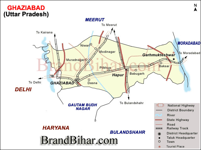
Ghaziabad district is bounded on the northwest by Baghpat District, on the north by Meerut District, on the east by Hapur District, on the southeast by Bulandshahr District, on the southwest by Gautam Buddha Nagar District, and on the west by Delhi state across the Yamuna River.
Geographical Location of Ghaziabad, Uttar Pradesh
The district of Ghaziabad is suitated in the middle of Ganga- Yamuna doab. In shape it is roughly rectangular, its lenght is 72 Kms. and its breadth is 37 Kms. On the north it is bouned by the district of Meerut, on the south by that of Bulandshahar & Gautambudh Nagar and on the south- west by the national capital Delhi State and on the east by the district Jyotibaphule nagar.
Ganga, Yamuna and Hindon are the main rivers flowing through the district and they are filled with water throughout the year. Other than these there are some small rainfed rivers, prominent among them is the Kali river. Apart from these rivers the Ganaga Canal flows through the district and irrigation work is carried out through different branches of Canal. The Ganga canal also caters the drinking water needs of the people of ghaziabad as well as Delhi.
Area & Population -
The total area of the district (according to CENSUS 1991) was 2590.0 sq. kms. but after the formation of the new district Gautam budh Nagar , it becomes 1933.3 sq. kms.
According to the census of 1991 the population of the district is 22,47,434. The density of the population per sq kms. is 1,127 and the population is 464.7 % higher than what it was ninety years ago.
Ghaziabad is a growing industrial city. Its population having increased from 5,81,886 (in 1901) to 27,03,933 (in 1991) mainly on account of its rapid industrilization and its proximity to Delhi. A large number of persons reside here but carry on their trades in Delhi or are employed there.
In the last twenty years Ghaziabad has expanded more than any other city. Before the formation of Ghaziabad district on 14th November 1976 it was a town of tehsil status of district Meerut but after it became a district it developed very fast and its population too increased in that proportation.
According to the 1991 census, total population of Ghaziabad district was 22,47,434, out of which 4,83,630 people are of schduled caste and 149 are of schduled tribe. There were 15,30,081 males and 12,05,397 females. Off all 9,40,469 people lived in villages and 18,55,009 people lived in the urban areas.
According to the 1991 census there were 9,80,938 literate people in the district out of which 6,62,402 were males and 3,18,536 females. Glancing at the urban population and comparing it with the previous census of the district, it is clear that the rural population has decreased considerably. It seems rapid establishment of new industrial institutions were the main reason for it. Increase in the urban population of Ghaziabad can be attributed to the influx of people to the city for earning their bread and butter and secondly as the residential problem of the Delhi metropolice is increasing, a large number of people are leaving it to settle in the nearby areas. As Ghaziabad is the most suitable place its urban population has increased rapidly.
Climate -
As it is connected to National capital Delhi, its temprature and rainfall are similar to Delhi. Rajasthan's dust storms and snowfall in the Himalayas, Kumaon and Garhwal hills name their impact in the weather regularly. The monsoon arrives in the district during the end of the June or the first week of July and normally it rains till october.
As in other districts of northern India mainly three seasons- summer, winter and rainy prevail here but sometimes due to severe snowfall in the Himalayas and Kumaon Hills adverse weather can also seen.
There is one municipal corporation (Ghaziabad), five municipal councils (Muradnagar, Modinagar, Hapur, Garhmuketeshwar and Pilkhua) and six town panchayats (town area Loni, Niwari, Patla, Dasna, Babugarh and Faridnagar) in the district. Ghaziabad was given the status of municipal corporation on 31st August 1994. There are 580 villages in the district out of which 535 villages are inhabited and 45 are non-inhabited.
Fair and Festivals
Feasting and Fasting are the special features of Hindu festivals which are celebrated here almost in the same manner as else where in the State. The important ones being described below :
Ram Navami falls on the nineth day of the bright half of the Chaitra to celebrate the birthday of Lord Rama. People fast on this day and the temples of Lord Rama are decorated & illuminated at night. The Ramayana is read in the temples and in the homes of many Hindus, large numbers of devotees flock to listen to the recitations.
Naga Panchami is celebrated on the fifth day of bright half of the Sravana to propitiate nagas or serpent gods. This is a big rainy season festival and women & girls sing songs. During these days swinging is very popular. Drawings of snakes are made on the walls of houses and are worshipped with milk, rice and flowers are offered to them.
Janamastmi falls on the eight day of the dark half of the Bhadra to commemorate the birthday of Lord Krishna. People fast throughout the day and break their fast with the eating of prasad which is distributed at midnight after the anniversary of the birth of Lord Krishna is celebrated.
There is a temple of Dudheshwar Nath in this palce about which a story goes that more than 250 years ago a Brahmana happened to pass by the site and saw a cow digging a hole in the earth into which she let her milk flow. Impressed by this the Hindus built a temple here and dedicated it ot the Dudheshwar Nath, which attracts about fifty thousand persons on the ocassion of Janmastmi.
Dasahra falls on the tenth of the bright half of the Asvina and is celebrated with the great enthusiasm in the district. It commemorates the victory of Rama over Ravana. Ramlila celebrations are held at differents place in the district and a big fair is held in the city of Ghaziaabad at Ramlila ground near ghantaghar.
Dipavali , the festival of lights, falls on the last day of the dark half of Kartika. Festivities start two days earlier with Dhanteras when metals utencils are purchasedas a token of prosperity. The next day, Narak Chaturdashi, a few small earthen lamps(diyas) are lit as a preliminary to the main day of the festival when every Hindu house in the districtis illuminatedand the goddess laxmi is worshipped. Businessman and Trades close their account on this day and start their new year and pray for prosperity in it. There is no fasting on this ocassion as Divali is regarded as a festival of feasting.
Shivratri is celebrated in honour of the birth of Lord Shiva and falls on the thirteen day of the dark half of Phalguna. A fast is observed during the day and a vigil is kept at night when the god is worshipped. The temples of Shiva are specially decorated and devotees offer water and flowers.
Holi is the last major festival of the Hindu calender and it falls on the full-moon day of Phalguna. In the villages people start the singing of phaags durings the nights, long before the actual day of the festival. Five or six days before the festival people start piling up firewood and bonfires are lit on the night of the festival itself. Ears of barley and wheat are also roasted in these fires. On the following day there is a common rejoicing water takes the form of people throwing coloured powder and coloured water on one another and paying visits to relations and friends.
The important festivals observed here by the Muslims are Barawfat, Shab-e-Barat, Id-ul-Fitr and Muharram which is an ocassion for mourning rather than a festivals.
The main festivals of the Christians are Christmas which falls on 25th Dec.; Good Friday.
The important festivals of the Sikhs are the birthday of their gurus, Nanak and Govind Singh;Lorhi and Baishaki.
A big bathing festival is observed on Kartikipurnima, the full moon day in the month of Kartika. People take a bath a bath in the Ganga and a big fair is held at Garhmukteshwar on this ocassion which is attended by about six lakhs of persons.
Ajrara ( Tahsil Hapur)
This village lies on the left bank of the Kali Nadi in Lat. 280 50' North and Long. 770 49' East, about 13 Kms north of Hapur and 7 Kms east of Kharkhauda which is both a Govt. Roadways Bus Station(on the Meerut-Hapur route) and a Railway Station (on the Meerut-Khurja line).
The place is said to have been the seat of Hindu monarchy begore the advent of the Muslims. The name owes its origin to a Yogi named Ajaipal who built a thakurdwara (temple) here and called it Ajaipara, the present name Ajrarabeing its corrupt form. Khwaja Basant Khan, who got the viilage in Jagir in the time of Muhammad Shah, built a fort here which was razed to the ground by the Marathas in 1794 when Fateh Ali Khan rebelled.
Bahadurgarh ( Tahsil Garh)
The village of Bahadurgarh lies in Lat. 280 40' North and Long. 780 7' East, in the south-eastern corner of the district, 78 Kms from Ghaziabad and 48 Kms from Hapur. From Wahabpur Thera, a village on the Garhmukteshwar-Bulandshahr road, a kutcha road about 3 kms long leads to this village.
The village was originally known as Garh Nana and was bestowed bu Jahangir upon Nawab Bahadur Khan, a Pathan, who changed the name to Bahadurgarh. About 6.5 kms north to this place(near Mustafabad) there are the ruins of a village known as Raja Karan-ka-Khera which is set to have been founded by Raja Karna (of Mahabharata fame).
The village was the original home of what has come to be known as Khurja pottery-an industry that was intriduced here from Multan about 250 years ago. It is also known locally for its handloom cloth. The products of the government dairy located here find a ready market in Delhi.
Dasna (Tahsil Ghaziabad)
This, the headquarters of the pargana, is suitated in Lat. 280 41' North and Long. 770 32' East, to the east of the Hapur road at a distance 10 kms from Ghziabad and 24 kms west of Hapur. The place gives its name to a railway station on the Ghaziabad-Moradabad branch line of the Northen Railway, the railway station actually lying within the limits of the adjoining village of Masuri.
Dasna owes its origin to Salarsi, a Rajput raja of Mahmud Ghajnavi's days. It is said that the raja had gone to bathe in the Ganga in order to get rid of his leprosy and, liking the place, settled down in it and also built a large fort there. While diging the foundation of the fort, a man is stated to have been fatally bitten by a snake, an incident which is said to have given the place its name, "DASNA", meaning to bite (used onluy for the bite of a snake). The village was ravaged by Ahmad Shah Abdali in 1760 when he pulled down the fort.
Dhaulana (Tahsil Ghaziabad)
The village lies on theroad which takes off at Dasna and joins the Meerut-Hapur-Bulandshahr road at Gulaothi and is 25 kms from tahsil headquarters. It is connected in the north with the Pilkhuwa railway station by a 8 kms kutcha raod. According to a local account, the village was founded by a man named Dhaul Singh about 1500 years ago and was named after him. It was sacked by the Sikhs in 1780 and again became the scene of action during the freedom struggle of 1857 in which the local Rajputs took a leading part, 14 of them being said to have been hanged. In 1957 the villagers raised a memorial in honour of these martyrs.
In a village there is a temple of Sati Malindi Devi, near which a fair is held. It is said that the villagers used to perform their worship in the village of Nagla Kashi but after a fight between the people of the two villages about a hundred years ago, those of Dhaulana built a temple in their village, which is still in existence.
Faridnagar ( Tahsil Modi Nagar)
faridnagar lies at a distance of 30 kms from the district headquarter and about 2 kms from Bhojpur block(on the Begumabad-hapur road) with which is connected by a metalled road. The palce was founded in the times of Akbar by Nawab Farid-ud-din Khan (who received the land in Jagir) and it was called Faridnagar after him.
Hapur ( pargana and tahsil Hapur)
the headquarter of the tahsil, this is the largest tahsil of the district and lies in Lat. 280 44' North and Long. 770 47' East, 34 kms east of Ghaziabad. Hapur is a railway junction where the Delhi-Moradabad and the Meerut-Khurja lines of the Northern Railway meet.
It is said that the place was founded about 983 A.D. by Haradatta, the Dor chieftain of Bulandshahr and Meerut, and was named haripur after him. Another derivation is from the word 'hapar' ,which signifies an orchard. A system of grants for the disabled and retired personnels of the army was introduced here by Perron(a French Military commander) and was adopted by the British for many years under which wastelands were cleared of jungles and were assigned to invalid pensioners. Ibrahim Ali, the tahsildar of Hapur, defended the town against Amir Khan Pindari and his 500 men in 1805. The forces of Walidad Khanof Malagarh planned an attack on the town during the struggle for freedom in 1857 but in was foiled by the Jats of Bhatona.
Hapur is a leading grain and jaggery market of the country and is well known for its papar (savoury comestible something like a large wafer). Brass utensils and handloom cloth manufactured here enjoy a local reputation. A market is held on Mondays in which the main commodities of sale are ghee nd earthern pots.
Formerly, there were in the town five gates known as the Delhi, Meerut, Garhmukteshwar, Kothi and Sikandra, but no vestiges of their existence are to be found apart from the localities of their names. The Jama Masjid( built during the reign of Aurangzeb in 1670) is the chief ornament of the town.
Jalalabad ( Tahsil Ghaziabad)
Jalalabad, which gives its name to the pargana, 15 kms from Ghaziabad. Tradition traces its origin to the days of Akbar when, it is said, it was founded by one Jalal-ud-din who named the village after himself. The important crops of the place are wheat, gram and sugar-cane and the main sources of irrigation are wells and the Jalalabad distributary of the Ganga canal.
Loni ( pargana Loni, tahsil Ghaziabad)
Loni, the headquarter of the pargana, about 17 kms north-west of Ghaziabad with which it is connected by a metalled road and about 10 kms from Shahdara(Delhi) to which it is linked by another metalled road running to Saharanpur. It also gives its name to a railway station on the Shahdara(Delhi)-Saharanpur Lght Railway line.
Considerable antiquity is assigned to the village by alocal tradition which goes that the rakshasa Lavanasur(who was killed by Rama's brother Shatrughna) ruled here, the place deriving its name from the first part of his name 'Lanvan', which is Sankrit means salt. Another tradition assosiates it with Lonnkaran, a raja(also known as Subkaran) after whom it was named Loni and whose fortress, it is said , existed here till 1789 when it was destroyed by Muhammad Shah, its bricks being used in the construction of a tank and a garden. According to a third account the name is derived from the word ' lon' because of its centre of a salt tract. The surrounding land once belonged to Prithviraja, the king of Delhi and the traces of a fort built by him are still in existence here. In December, 1398, Timur captured it- killing, according to local account, a lakh of its inhabitants and making the fortress the headquarters of his army. Till the begining of the present century there were two groves here, one of the Kharanji Bagh and other located at a site known as Uldipur, both planted by Zinat Mahal(the wife of the Emperor bahadur Shah) which were confiscated during the freedom struggle of 1857 and were sold to Shaikh Ilahi Baksh of Meerut. A third grove called Ranap, said to have been laidout about 500 years ago by the wife of an emperor of Delhi, was brought under cultivation in the last quarter of the nineteenth century but came to be inhabited some time later, the locality being known as Abadi Bagh Ranap, the boundary wall of the grove still being in existence. Other old buildings of the place include two mosques on a mound and a Siva temple built about a hundred years ago.
Modinagar ( tahsil Modinagar)
Modinagar lies in Lat. 280 50' north and Long. 770 35' east, 25 kms north-east of Ghaziabad on the Delhi-Mussoorie National Highway (NH-58) . Parallel to this road runs the Delhi-Saharan section of the Northern Railway with a railway station here. A metalled road ,going to Hapur, passes through the town. It is of recent origin, having been founded by Gujar Mal Modi who established a sugar factory here in 1933, named the place after himself. Begumabad, which has contributed about 571 acres of its area to the making of this town, is a much older place and is said to have been founded by one Nawab Zafar Ali and to have been named Begumabad by a lady of the royal family of Delhi when it passed into here hands. Its importance has declined considerably with the growth of Modinagar as an industrial town. Sugar, vegetable oil, textiles(including rayon & silk), soap,paints, varnishes, and lanterns glycerine, cotton yarn, torches, carbon-di-oxide and flour are produced at Modinagar. A temple (built in the early nineteenth century by Rani Bala Bai Sindhia) which was formerly in the village of Begumabad, is now included in the notified area of Modinagar.
Mohan Nagar ( Tahsil Ghaziabad)
Mohan Nagar, a modern industrial township lies in Lat. 280 41' North and Long. 770 24' East, on the G.T. road about 7 kms west of Ghaziabad, and 16 kms east of Delhi, the Sahibabad railway station lying about 3 kms south-west of the place. It was founded in 1958 by N.N. Mohan and is named after him. It has a yeast and malt extract plant, a brewery and a distillery, a cold storage, an ice factory and a plant for soft drink, all equipped with modern machinery mostly manufactured at workshops in the township itself.
Murad Nagar ( Tahsil Modinagar)
A town in Lat. 280 47' North and Long. 770 33' east, Muradnagar is suitated at a distance of about 14 kms from Ghaziabad. The place gives its name to a railway station on the Delhi-Saharanpur section of the Northern Railway, which lies nearly 3 kms south-east of the town.
It was founded about four hundred year ago by Mirza Muhammad Murad Mughal whose mausoleum still stands near the town. The place possesses an ordinance factory ( of the Government of India).
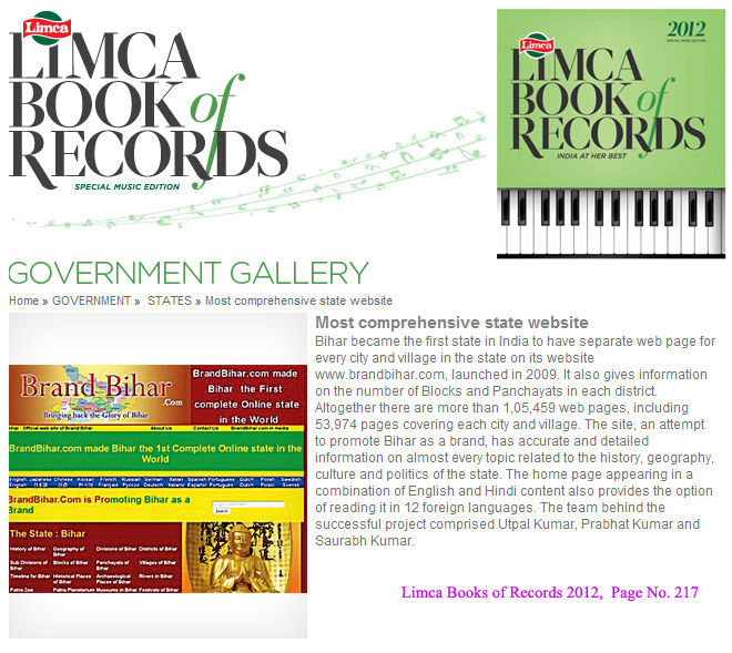
Bihar became the first state in India to have separate web page for every city and village in the state on its website www.brandbihar.com (Now www.brandbharat.com)
See the record in Limca Book of Records 2012 on Page No. 217